Approximate Location Map
Large Map »
Latitude: 52.3953 / 52°23'42"N
Longitude: 0.2661 / 0°15'57"E
OS Eastings: 554284
OS Northings: 279887
OS Grid: TL542798
Mapcode National: GBR M6H.VF2
Mapcode Global: VHHJD.K2J3
Plus Code: 9F4297W8+4C
Entry Name: 96, Broad Street
Listing Date: 19 June 1972
Grade: II
Source: Historic England
Source ID: 1167137
English Heritage Legacy ID: 48675
ID on this website: 101167137
Location: Ely, East Cambridgeshire, CB7
County: Cambridgeshire
District: East Cambridgeshire
Civil Parish: Ely
Built-Up Area: Ely
Traditional County: Cambridgeshire
Lieutenancy Area (Ceremonial County): Cambridgeshire
Church of England Parish: Ely
Church of England Diocese: Ely
Tagged with: Building
BROAD STREET
1.
1082
(North West Side)
TL 5479 2/108 No 95
II GV
2.
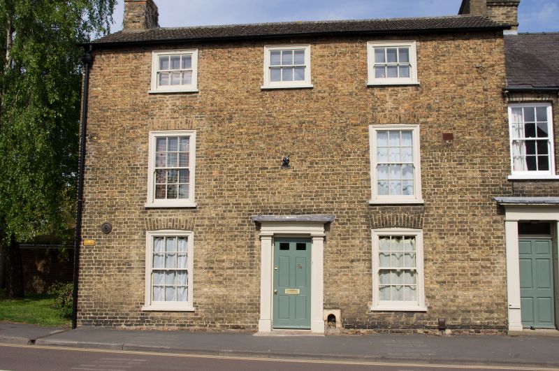
An early C19 gault brick house. 3 storeys. J window range (2 window range
on the 1st storey), double-hung sashes with glazing bars, in flush cased
frames. A central 6-panel door has a stucco doorcase, with pilasters and
cornice. Roof slate.
Nos 90 to 96 (even) with Nos 41 & 4lA form a group.
Listing NGR: TL5428479887
External links are from the relevant listing authority and, where applicable, Wikidata. Wikidata IDs may be related buildings as well as this specific building. If you want to add or update a link, you will need to do so by editing the Wikidata entry.


Other nearby listed buildings
