Approximate Location Map
Large Map »
Latitude: 51.7133 / 51°42'48"N
Longitude: -1.9655 / 1°57'55"W
OS Eastings: 402479
OS Northings: 201624
OS Grid: SP024016
Mapcode National: GBR 3QY.FX7
Mapcode Global: VHB2Q.W68D
Plus Code: 9C3WP27M+8Q
Entry Name: Wall, Railings and Gate Pier Attached to Numbers 23 and 25
Listing Date: 19 January 1981
Grade: II
Source: Historic England
Source ID: 1187533
English Heritage Legacy ID: 365466
ID on this website: 101187533
Location: Cirencester, Cotswold, Gloucestershire, GL7
County: Gloucestershire
District: Cotswold
Civil Parish: Cirencester
Built-Up Area: Cirencester
Traditional County: Gloucestershire
Lieutenancy Area (Ceremonial County): Gloucestershire
Church of England Parish: Cirencester St John the Baptist
Church of England Diocese: Gloucester
Tagged with: Wall Guard rail
CIRENCESTER
SP0201 WATERMOOR ROAD
578-1/6/328 (East side)
19/01/81 Nos.23 AND 25
and attached wall, railings and
gate pier
GV II
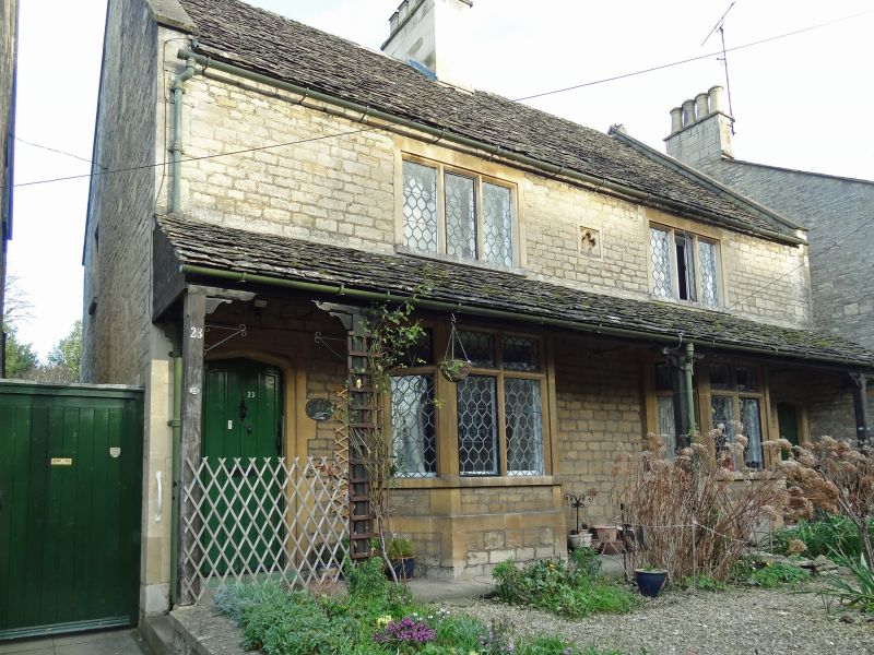
Pair of almshouses. Probably late C19. Coursed squared
limestone; stone slate roof with coped verges with trefoil
stops at apex; shared ashlar ridge stack to centre with C19
square section clay chimney pots. 2-storey 2-window range.
First floor has two 3-light chamfered stone mullion windows
with hexagonal pattern leaded light casements; ground floor
has 2 canted bays with plinths, each of 4 lights with
chamfered stone mullion-and-transoms and hexagonal pattern
leaded light casements. 2 plank doors with Tudor-arched heads
in chamfered stone surrounds. Verandah to ground floor has
stone-slated roof supported on 4 square-section timber posts
with stone bases and bracketed tops. Small ashlar panel to
first floor centre with incised quatrefoil decoration. Flush
quoins to left and right angles. Attached wall approximately
2m high to right side and front in coursed squared limestone
rubble with ashlar coping ramps down to approximately 1m high
to front where it is topped by light railings of round section
with shaped heads, similar dog bars, 3 square section posts
with anthemoin heads and curved backstays. Gate pier to left
with shallow pyramidal cap. INTERIORS not inspected.
Listing NGR: SP0247901623
External links are from the relevant listing authority and, where applicable, Wikidata. Wikidata IDs may be related buildings as well as this specific building. If you want to add or update a link, you will need to do so by editing the Wikidata entry.


Other nearby listed buildings
