Approximate Location Map
Large Map »
Latitude: 50.8432 / 50°50'35"N
Longitude: -0.2205 / 0°13'13"W
OS Eastings: 525383
OS Northings: 106357
OS Grid: TQ253063
Mapcode National: GBR JNT.52J
Mapcode Global: FRA B6FW.1XL
Plus Code: 9C2XRQVH+7R
Entry Name: The Stags Head Public House
Listing Date: 22 September 1971
Last Amended: 2 November 1992
Grade: II
Source: Historic England
Source ID: 1187559
English Heritage Legacy ID: 365542
Also known as: Stags Head
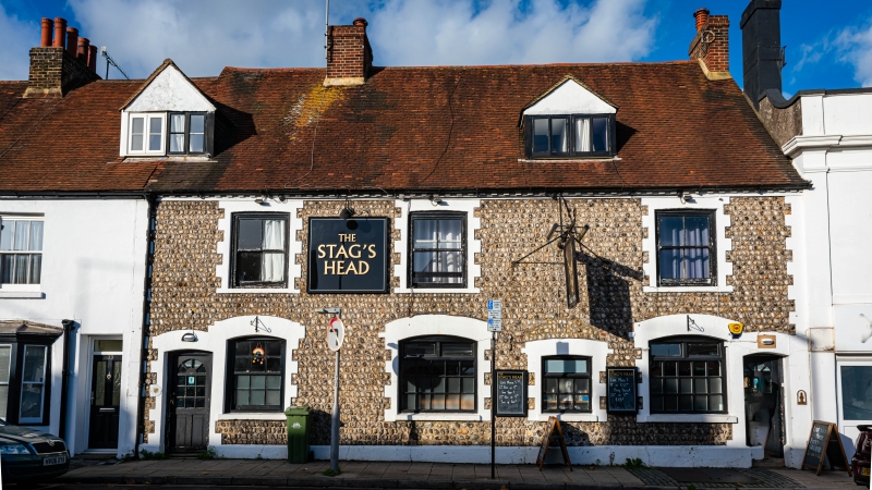
The Stags Head, Brighton
ID on this website: 101187559
Location: Portslade-by-Sea, Brighton and Hove, West Sussex, BN41
County: The City of Brighton and Hove
Electoral Ward/Division: South Portslade
Parish: Non Civil Parish
Built-Up Area: Portslade-by-Sea
Traditional County: Sussex
Lieutenancy Area (Ceremonial County): East Sussex
Church of England Parish: Portslade St Nicolas and St Andrew and Mile Oak The Good Shepherd
Church of England Diocese: Chichester
Tagged with: Pub
HOVE
TQ2506SW HIGH STREET, Portslade
579-1/9/161 (North side)
22/09/71 Nos.35 AND 37
The Stags Head Public House
(Formerly Listed as:
PORTSLADE
HIGH STREET, Old Portslade
The Stag Inn)
GV II
Also known as: St George Public House HIGH STREET.
Inn. Late C17, subsequently altered, refenestrated late C19,
altered late C20. Faced with coursed pebbles, dentil brick
cornice, rendered brick quoins and dressings, steeply pitched
clay tile roof, brick stacks gable end right and between first
and second bays left. Plan: possibly two cottages originally,
subsequently three, now one. 2 storeys plus attic, 3 bays;
gabled dormer to right, another at junction with cottage
adjoining to left (not included), first floor sash windows
with one vertical glazing bar, ground floor 4 window openings
with cambered heads, probably inserted early C19,
refenestrated late C19, entrances end bays right and left
through late C20 doors. Interior: ground floor altered. Title
deeds for the property said to date from 1674 are on display
in the saloon bar. The inn was connected with the brewery to
the east, now known as Le Carbone, South Street (not included)
and its predecessor in Drove Road (qv).
Listing NGR: TQ2538306357
External links are from the relevant listing authority and, where applicable, Wikidata. Wikidata IDs may be related buildings as well as this specific building. If you want to add or update a link, you will need to do so by editing the Wikidata entry.


Other nearby listed buildings
