Approximate Location Map
Large Map »
Latitude: 52.191 / 52°11'27"N
Longitude: -1.7014 / 1°42'5"W
OS Eastings: 420508
OS Northings: 254798
OS Grid: SP205547
Mapcode National: GBR 4LT.NMW
Mapcode Global: VHBY0.G6D5
Plus Code: 9C4W57RX+CC
Entry Name: Old Tramway Bridge
Listing Date: 25 October 1951
Last Amended: 4 April 1994
Grade: II
Source: Historic England
Source ID: 1187828
English Heritage Legacy ID: 366338
ID on this website: 101187828
Location: Stratford-upon-Avon, Stratford-on-Avon, Warwickshire, CV37
County: Warwickshire
District: Stratford-on-Avon
Civil Parish: Stratford-upon-Avon
Built-Up Area: Stratford-upon-Avon
Traditional County: Warwickshire
Lieutenancy Area (Ceremonial County): Warwickshire
Church of England Parish: Stratford on Avon Holy Trinity
Church of England Diocese: Coventry
Tagged with: Bridge
STRATFORD-UPON-AVON
SP2054 OLD TRAMWAY WALK
604-1/6/8 (North West side)
25/10/51 Old Tramway Bridge
(Formerly Listed as:
BANBURY ROAD, Bridgetown
Old Tramway Bridge)
GV II
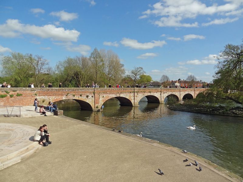
Tramway bridge, now footbridge. 1823 with later parapets. John
Rastrick, engineer; for Stratford and Moreton Tramway. Brick
with ashlar dressings. 8 elliptical arches, that to south east
end a flood arch, with piers on cutwaters to both sides.
Ashlar-coped brick parapets. Built to carry a horse tramway
from the Stratford Wharf to Moreton-in-Marsh. The tramway,
which was originally intended to be extended to London, had a
branch to Shipston-on-Stour. It was bought by the Oxford,
Worcester and Wolverhampton Railway in 1847 and closed, except
for the branch line, in 1881; details of history given on a
restored truck (not included) preserved approx. 60m to north
of bridge. The bridge is an important element in the landscape
around the Shakespeare Memorial Theatre.
(Fogg N: Stratford-upon-Avon: Portrait of a Town: Chichester:
1986-: 120-4, 156, 167N; Buildings of England: Pevsner N:
Warwickshire: Harmondsworth: 1966-: 416).
Listing NGR: SP2050854798
External links are from the relevant listing authority and, where applicable, Wikidata. Wikidata IDs may be related buildings as well as this specific building. If you want to add or update a link, you will need to do so by editing the Wikidata entry.


Other nearby listed buildings
