Latitude: 54.0063 / 54°0'22"N
Longitude: -1.4708 / 1°28'14"W
OS Eastings: 434780
OS Northings: 456827
OS Grid: SE347568
Mapcode National: GBR LQ53.CL
Mapcode Global: WHD9L.CKVK
Plus Code: 9C6W2G4H+GM
Entry Name: Castle Mill: Central Building at Right Angle to Road
Listing Date: 25 March 1983
Last Amended: 12 December 1985
Grade: II
Source: Historic England
Source ID: 1191203
English Heritage Legacy ID: 330877
ID on this website: 101191203
Location: Knaresborough, North Yorkshire, HG5
County: North Yorkshire
District: Harrogate
Civil Parish: Knaresborough
Built-Up Area: Knaresborough
Traditional County: Yorkshire
Lieutenancy Area (Ceremonial County): North Yorkshire
Church of England Parish: Knaresborough
Church of England Diocese: Leeds
Tagged with: Mill building
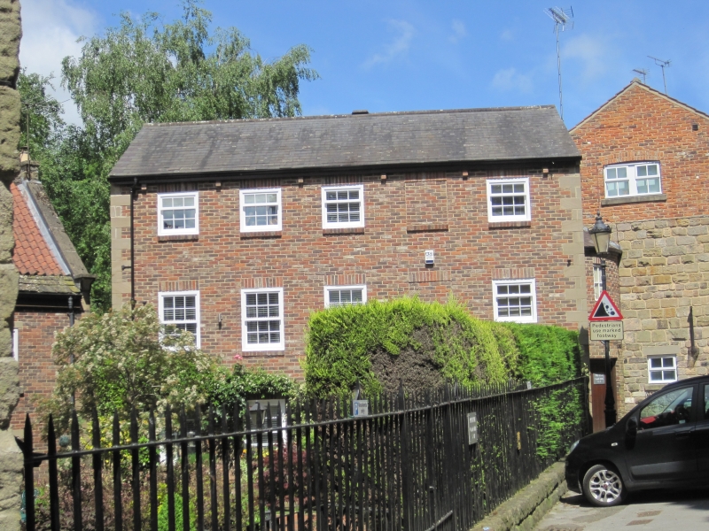
SE 3456 KNARESBOROUGH WATERSIDE
(south side)
8/207 Castle Mill: central
building at right-angle
to road (formerly listed
25.3.83 as Block B under Castle Mills
(Consisting of blocks A to E))
GV II
Mill building, now derelict. Mid-late C18 with later alterations. Brick,
English bond, with sandstone details; stone slate roof. 3 storeys, 5 bays
and linked at the north-east corner to road-side range (q.v.). Stone plinth
and quoins. Right - inserted 4-panel door with blocked window right again
and 3 C20 windows to left. First floor: blocked window far right; 4 square
windows with flush wood frames, the second from the left probably original,
with 3 horizontal lights - the lower light boarded, centre light of 4 panes,
and top light open (in some cases also boarded). Wooden lintels, 2 to right
repaired in cement. Second floor: original window bay 4, the remainder
blocked. Rear - ground floor: board door bay 2, windows boarded over.
First floor: 3 windows with 3 horizontal lights, 8-pane fixed window to
right. Second floor: left window blocked, remainder of 3 horizontal lights.
Right return: remains of projecing brick stack on stone corbels at first
floor. Interior not inspected at resurvey, but reported to contain a stone-
vaulted cellar and roof structure of 3 king post trusses in soft wood
(Harrogate Borough Council, p 10). To left- 2-storey linking range of brick
with slate roof, (between this building and range to south-west, formerly
block C - q.v.), built after 1851 and not of special interest. This
building is possibly on the site of the paper mill complex operated in 1771
by John Lomas, and converted to a cotton mill in 1791. There was a low
range attached to the east end of the south side and shown in the Ordnance
Survey map of 1851. Harrogate Borough Council, The Future of Castle Mills,
1983. B Jennings, Harrogate and Knaresborough, 1970, p 264.
Ordnance Survey, Map of Knaresborough, Scale 5' to 1 mile, 1851.
Listing NGR: SE3478056827
External links are from the relevant listing authority and, where applicable, Wikidata. Wikidata IDs may be related buildings as well as this specific building. If you want to add or update a link, you will need to do so by editing the Wikidata entry.


Other nearby listed buildings