Approximate Location Map
Large Map »
Latitude: 51.061 / 51°3'39"N
Longitude: -0.3293 / 0°19'45"W
OS Eastings: 517173
OS Northings: 130404
OS Grid: TQ171304
Mapcode National: GBR HJN.FKN
Mapcode Global: FRA B669.TT9
Plus Code: 9C3X3M6C+C7
Entry Name: 14, the Causeway
Listing Date: 20 May 1949
Grade: II
Source: Historic England
Source ID: 1191566
English Heritage Legacy ID: 298120
ID on this website: 101191566
Location: Horsham, West Sussex, RH12
County: West Sussex
District: Horsham
Electoral Ward/Division: Denne
Parish: Non Civil Parish
Built-Up Area: Horsham
Traditional County: Sussex
Lieutenancy Area (Ceremonial County): West Sussex
Church of England Parish: Horsham St Mary the Virgin
Church of England Diocese: Chichester
Tagged with: Building
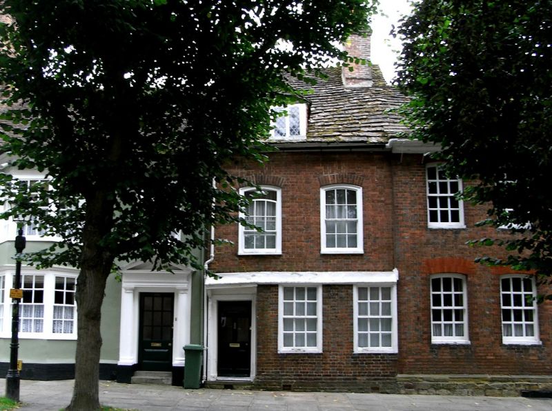
1. THE CAUSEWAY
1236
(East Side)
No 14
TQ 1730 1/6 20.5.49.
II GV
2.
Early C18. 2 storeys and attic. 2 windows. 1 dormer. Red brick. Eaves cornice.
Horsham slab roof. 1st floor windows with segmental heads. Sashes, glazing bars
intact. Wide glazing bars to ground floor windows. Doorway in frame with flat
hood over supported on brackets, and 5-panel moulded door with upper 3 panels cut
away for glazing.
All the listed buildings in The Causeway form a very important group with all the
listed buildings in Market Square and with South Street.
Listing NGR: TQ1717330404
External links are from the relevant listing authority and, where applicable, Wikidata. Wikidata IDs may be related buildings as well as this specific building. If you want to add or update a link, you will need to do so by editing the Wikidata entry.


Other nearby listed buildings
