Approximate Location Map
Large Map »
Latitude: 53.5659 / 53°33'57"N
Longitude: -1.0808 / 1°4'50"W
OS Eastings: 460979
OS Northings: 408095
OS Grid: SE609080
Mapcode National: GBR NWW6.TF
Mapcode Global: WHFF1.CMLN
Plus Code: 9C5WHW89+9P
Entry Name: Barn and attached cartshed approximately 50 metres to south-east of Church of St Oswald
Listing Date: 23 March 1988
Grade: II
Source: Historic England
Source ID: 1191819
English Heritage Legacy ID: 334905
ID on this website: 101191819
Location: Long Sandall, Doncaster, South Yorkshire, DN3
County: Doncaster
Civil Parish: Barnby Dun with Kirk Sandall
Built-Up Area: Doncaster
Traditional County: Yorkshire
Lieutenancy Area (Ceremonial County): South Yorkshire
Church of England Parish: Kirk Sandall and Edenthorpe Church of the Good Shepherd
Church of England Diocese: Sheffield
Tagged with: Barn
This list entry was subject to a Minor Amendment on 8 November 2021 to reformat text to current standards
SE 60 NW
8/41
BARNBY DUN WITH KIRK SANDALL
Kirk Sandall
MOOR LANE (south side)
Barn and attached cartshed approximately 50 metres to south-east of Church of St. Oswald
GV
II
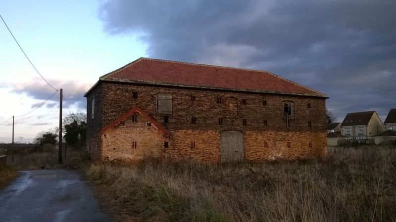
Barn and cartshed. Dated 1824. Red brick in English garden wall bond, stone slate eaves courses to pantile roof (now coated). Two-storey, five-bay barn with one-storey, five-bay cartshed attached to front left (west side).
Barn: central waggon entrance with boarded doors beneath basket arch with keystone; three rows of paired slit vents, iron tie-plates flanking the vents above central door, in form of the initials G (?) M; basket-arched blind recess over door has datestone inscribed " 18 24" , flanking hatches with boarded doors and basket arches; dentilled eaves to hipped roof. Right return has large C20 opening beneath steel girder.
Cartshed: three open-fronted bays to right with cylindrical brick piers and domed stone abaci supporting wall plate; two bays on left infilled and with wooden doors; hipped left end to roof.
Listing NGR: SE6097908095
External links are from the relevant listing authority and, where applicable, Wikidata. Wikidata IDs may be related buildings as well as this specific building. If you want to add or update a link, you will need to do so by editing the Wikidata entry.


Other nearby listed buildings
