Latitude: 50.3419 / 50°20'30"N
Longitude: -3.5664 / 3°33'59"W
OS Eastings: 288630
OS Northings: 50277
OS Grid: SX886502
Mapcode National: GBR QT.YTKR
Mapcode Global: FRA 38F4.6DX
Plus Code: 9C2R8CRM+PC
Entry Name: Walls of the Ruined Fortalice
Listing Date: 11 December 1969
Last Amended: 23 February 1994
Grade: I
Source: Historic England
Source ID: 1197566
English Heritage Legacy ID: 387142
ID on this website: 101197566
Location: Warfleet, South Hams, Devon, TQ6
County: Devon
District: South Hams
Civil Parish: Dartmouth
Traditional County: Devon
Lieutenancy Area (Ceremonial County): Devon
Church of England Parish: Dartmouth Townstal
Church of England Diocese: Exeter
Tagged with: Wall
DARTMOUTH
SX8850 DARTMOUTH CASTLE
673-1/7/11 Walls of the ruined Fortalice
11/12/69
(Formerly Listed as:
Dartmouth Castle)
GV I
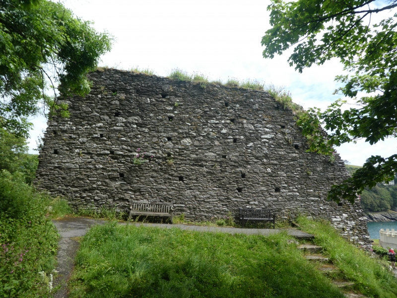
Ruined wall. Part of curtain wall from the original
fortification on the site. Late C14, some C18 alterations.
Local stone rubble. A section of ruined wall stands to
south-west of the main castle complex with remains of a
circular mural tower. Masonry includes regular series of
putlog holes. The stone steps in the tower are thought to be
from the C18 when it was adapted as a garden feature.
Scheduled Ancient Monument.
(Archaeologia: O'Neil BH St J: Dartmouth Castle and other
defences of Dartmouth Haven: 1935-: P.129-157; Saunders AD:
Dartmouth Castle, Devon: HMSO: 1986-).
Listing NGR: SX8862350276
External links are from the relevant listing authority and, where applicable, Wikidata. Wikidata IDs may be related buildings as well as this specific building. If you want to add or update a link, you will need to do so by editing the Wikidata entry.


Other nearby listed buildings