Approximate Location Map
Large Map »
Latitude: 54.5411 / 54°32'28"N
Longitude: -1.926 / 1°55'33"W
OS Eastings: 404882
OS Northings: 516208
OS Grid: NZ048162
Mapcode National: GBR GHZX.TX
Mapcode Global: WHB4L.D421
Plus Code: 9C6WG3RF+CH
Entry Name: 22, Bridgegate
Listing Date: 24 February 1950
Last Amended: 28 November 1994
Grade: II
Source: Historic England
Source ID: 1201055
English Heritage Legacy ID: 388633
ID on this website: 101201055
Location: Startforth, County Durham, DL12
County: County Durham
Civil Parish: Barnard Castle
Built-Up Area: Barnard Castle
Traditional County: Durham
Lieutenancy Area (Ceremonial County): County Durham
Church of England Parish: Barnard Castle with Whorlton
Church of England Diocese: Durham
Tagged with: Building
BARNARD CASTLE
NZ0416SE BRIDGEGATE
770-1/5/4 (West side)
24/02/50 No.22
(Formerly Listed as:
BRIDGEGATE
No.28
and Old mill building to rear of
No.28)
GV II
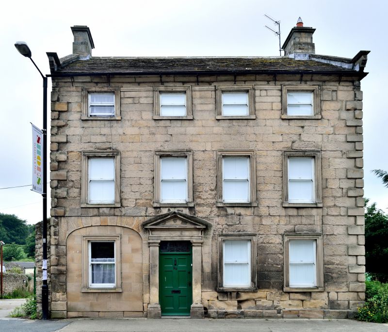
Formerly known as: No.28 Banner's Mill House BRIDGEGATE.
House, probably originally mill manager's house. Mid-late C18.
Restored 1970s. Ashlar with plinth and rusticated quoins;
returns of coursed rubble. Roof of renewed stone slates with
stone gable copings and ashlar chimneys.
EXTERIOR: 3 storeys; 4-window range. Renewed 6-panel door and
plain overlight in doorcase of Tuscan pilasters and pedimented
entablature in second bay. Elliptical carriage arch to left of
door is now blocked and has sash window inserted. All windows
have renewed plain sashes in architraves, those on second
floor smaller with heads projecting from architrave of eaves
entablature with gutter cornice. Roof has stone gable copings
on kneelers with pendant moulding, and corniced end chimneys.
Right return has plain stone surrounds to sashes on two
intermediate levels. Left return has lower range linking with
former mill (qv).
INTERIOR: close string dogleg stair of four flights with
ramped rail, urn and skittle balusters, and grip handrail.
Front right ground floor room has corniced raised and fielded
panelling above dado level; dado removed.
Listing NGR: NZ0488216208
External links are from the relevant listing authority and, where applicable, Wikidata. Wikidata IDs may be related buildings as well as this specific building. If you want to add or update a link, you will need to do so by editing the Wikidata entry.


Other nearby listed buildings
