Approximate Location Map
Large Map »
Latitude: 51.9928 / 51°59'33"N
Longitude: -2.1562 / 2°9'22"W
OS Eastings: 389373
OS Northings: 232714
OS Grid: SO893327
Mapcode National: GBR 1JR.1NZ
Mapcode Global: VH93T.K5ZP
Plus Code: 9C3VXRVV+4G
Entry Name: 17, Barton Street
Listing Date: 4 March 1952
Grade: II
Source: Historic England
Source ID: 1201182
English Heritage Legacy ID: 376606
ID on this website: 101201182
Location: Tewkesbury, Gloucestershire, GL20
County: Gloucestershire
District: Tewkesbury
Civil Parish: Tewkesbury
Built-Up Area: Tewkesbury
Traditional County: Gloucestershire
Lieutenancy Area (Ceremonial County): Gloucestershire
Church of England Parish: Tewkesbury St Mary the Virgin (Tewkesbury Abbey)
Church of England Diocese: Gloucester
Tagged with: Building
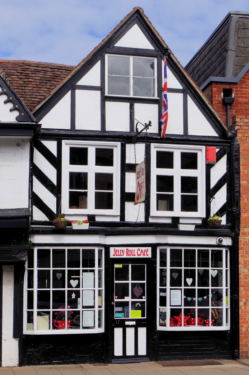
TEWKESBURY
SO8932 BARTON STREET
859-1/6/20 (North side)
04/03/52 No.17
GV II
Small house in row, with cafe; possibly the solar wing to
adjoining house. Late C16 refronting of C15 structure.
Timber-framed with plaster panels, tile roof. Right-angle plan
with gable facing street.
2 storeys, attic, and basement, 2-windowed. A small 2-light in
the gable above 2-light casements with transom and horizontal
bar at first floor, and fine late C18 or early C19 multi-pane
canted bow shop fronts flanking a part-glazed door, under
simple fascia. A basement grille and access under the
right-hand window. The ornamental-panelled and studded
frontage has herringbone framing at first floor, with
small-panel framing to the gable, which runs back to the main
transverse roof, continuous with that to No.16 (qv) adjoining.
The ground floor has a pair of heavy posts with a jetty
bracket near the front, with a further pair of posts and heavy
transverse beam to a short bay within. To rear, the C15
structure has later alterations including a late C16
right-angled bay.
INTERIOR includes C15 three-bay roof with clasped purlins and
windbracing to first floor of chamber originally open to roof;
floor levels with beams dating from late C16 remodelling.
The C15 structure probably functioned as a solar wing to a
large late medieval hall house, probably No.16 (qv). The shop
front is a notable and remarkably complete example of its
date.
Listing NGR: SO8937332714
External links are from the relevant listing authority and, where applicable, Wikidata. Wikidata IDs may be related buildings as well as this specific building. If you want to add or update a link, you will need to do so by editing the Wikidata entry.


Other nearby listed buildings
