Latitude: 54.5379 / 54°32'16"N
Longitude: -1.9189 / 1°55'8"W
OS Eastings: 405345
OS Northings: 515854
OS Grid: NZ053158
Mapcode National: GBR HH1Z.C1
Mapcode Global: WHB4L.H6GH
Plus Code: 9C6WG3QJ+5C
Entry Name: Byres and Sheds to Demesnes Mill
Listing Date: 28 November 1994
Grade: II
Source: Historic England
Source ID: 1201344
English Heritage Legacy ID: 388700
ID on this website: 101201344
Location: Lendings, County Durham, DL12
County: County Durham
Civil Parish: Barnard Castle
Traditional County: Durham
Lieutenancy Area (Ceremonial County): County Durham
Church of England Parish: Barnard Castle with Whorlton
Church of England Diocese: Durham
Tagged with: Cowshed
BARNARD CASTLE
NZ01NE GRAY LANE 770-1/2/73 (East side (off)) Byres and sheds to Demesnes Mill
GV II
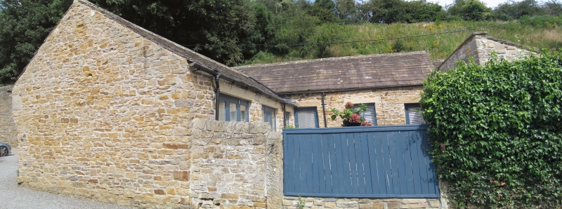
Shown on OS as Demesnes Mill Farm. Byres and sheds to Demesne Mill (qv). Late C18/early C19. Rubble with ashlar dressings; roof of graduated stone slates with stone ridges. East-west range with lower ranges breaking forward from centre and east end. Main range one storey, 4 bays. Boarded doors in first 3 bays, Dutch in first and third, with flat stone lintels; small horizontal 6-pane light in fourth bay with wood lintel and stone sill. Left return has small blocked light at right with stone lintel and sill, and pipe vents in gable peak. Breaking forward from third bay and partly obscuring door lintel, west elevation of cart shed has double-boarded doors at right, and blocked vehicle door at left. Boarded doors in east cross-range breaking forward from end of main building. First cross-range has swept eaves; second cross-range has monopitch roof sloping down to rear. INTERIOR: not inspected. Included for group value.
Listing NGR: NZ0534515854
External links are from the relevant listing authority and, where applicable, Wikidata. Wikidata IDs may be related buildings as well as this specific building. If you want to add or update a link, you will need to do so by editing the Wikidata entry.


Other nearby listed buildings