Latitude: 50.5455 / 50°32'43"N
Longitude: -2.4371 / 2°26'13"W
OS Eastings: 369122
OS Northings: 71840
OS Grid: SY691718
Mapcode National: GBR PZ.3MY9
Mapcode Global: FRA 57SM.8CY
Plus Code: 9C2VGHW7+64
Entry Name: Wesleyan School with Boundary Wall
Listing Date: 17 May 1993
Grade: II
Source: Historic England
Source ID: 1203081
English Heritage Legacy ID: 381934
ID on this website: 101203081
Location: Easton, Dorset, DT5
County: Dorset
Civil Parish: Portland
Built-Up Area: Weston
Traditional County: Dorset
Lieutenancy Area (Ceremonial County): Dorset
Church of England Parish: Portland All Saints
Church of England Diocese: Salisbury
Tagged with: School building
PORTLAND
SY6871 EASTON SQUARE, Easton 969-1/4/40 (West side) Wesleyan School with boundary wall
GV II
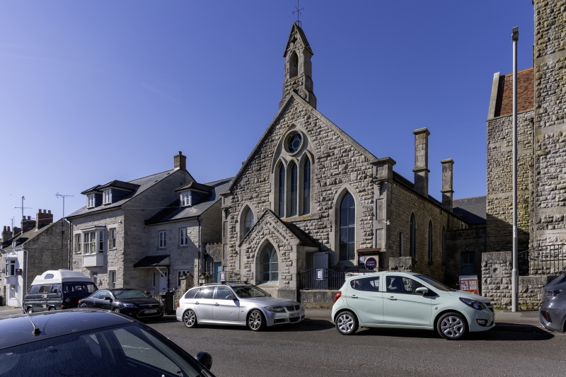
Church hall, formerly Wesleyan school. Dated 1878 on porch. Coursed and squared slightly rock-faced Portland stone or rubble, slate roofs. A cruciform building, but probably built first as a single hall to which 'transept' and rear wing added (see coped gable to rear of front block). E front has triple lancet with oculus in plate tracery to pointed arch with drip course, flanked at lower level with single lancets, all under coped gable with bellcote; gabled square porch with blocked plank doors to pointed arch under inscription WESLEYAN 1878 SCHOOL. To right and left are plank doors in deep chamfered surrounds. Rubble returns, that to S partly concealed, but includes one pointed light, and to N are 3 pointed lights to flush quoins and heavy cills, and 2 lofty eaves stacks; this side linked to main Church (qv) by 1906 wall with door. South 'transept' coped gable with kneelers over plain wall. Back wing has 3 tall flush lights under coped gable with kneelers, and a central ridge stack. In the re-entrant on N side a boiler house and large square stack, also a small-paned casement. Across front of property a dwarf wall, formerly with railings; at the left end a tall square gate pier to cross-gabled roll-top capping. Included mainly for group value.
Listing NGR: SY6912271840
External links are from the relevant listing authority and, where applicable, Wikidata. Wikidata IDs may be related buildings as well as this specific building. If you want to add or update a link, you will need to do so by editing the Wikidata entry.


Other nearby listed buildings