Latitude: 52.5724 / 52°34'20"N
Longitude: -2.1388 / 2°8'19"W
OS Eastings: 390692
OS Northings: 297189
OS Grid: SO906971
Mapcode National: GBR 19Q.Z7
Mapcode Global: WHBFZ.3LTR
Plus Code: 9C4VHVC6+XF
Entry Name: Fountain to West of Royal Wolverhampton School
Listing Date: 31 March 1992
Grade: II
Source: Historic England
Source ID: 1207644
English Heritage Legacy ID: 378521
ID on this website: 101207644
Location: Goldthorn Hill, Wolverhampton, West Midlands, WV3
County: City of Wolverhampton
Electoral Ward/Division: Blakenhall
Parish: Non Civil Parish
Built-Up Area: Wolverhampton
Traditional County: Staffordshire
Lieutenancy Area (Ceremonial County): West Midlands
Church of England Parish: Central Wolverhampton
Church of England Diocese: Lichfield
Tagged with: Fountain
WOLVERHAMPTON
SO99NW PENN ROAD
895-1/5/36 (East side)
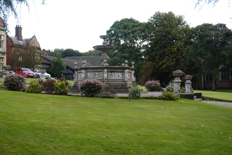
Fountain to West of Royal
Wolverhampton School
GV II
Fountain. 1864. Ashlar. Octagonal structure. Basin with plinth
on 3 steps has scrolls to angles and relief panels depicting
works of charity: Feeding the Hungry, Clothing the Naked etc;
one polished granite panel to west has inscription recording
charity of Mary Rogers, wife of one of the directors of the
orphanage; cornice with lettering giving titles of reliefs; 8
ball finials; bowl on baluster stem has lion masks to rim;
plain top bowl.
Listing NGR: SO9069297189
External links are from the relevant listing authority and, where applicable, Wikidata. Wikidata IDs may be related buildings as well as this specific building. If you want to add or update a link, you will need to do so by editing the Wikidata entry.


Other nearby listed buildings