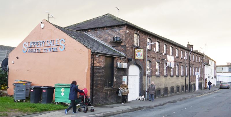
Latitude: 52.3429 / 52°20'34"N
Longitude: -2.2766 / 2°16'35"W
OS Eastings: 381249
OS Northings: 271681
OS Grid: SO812716
Mapcode National: GBR 0C0.172
Mapcode Global: VH920.HC9S
Plus Code: 9C4V8PVF+58
Entry Name: 12, Foundry Street
Listing Date: 18 May 1976
Last Amended: 11 October 1991
Grade: II
Source: Historic England
Source ID: 1210052
English Heritage Legacy ID: 393324
ID on this website: 101210052
Location: Stourport-on-Severn, Wyre Forest, Worcestershire, DY13
County: Worcestershire
District: Wyre Forest
Civil Parish: Stourport-on-Severn
Built-Up Area: Stourport-on-Severn
Traditional County: Worcestershire
Lieutenancy Area (Ceremonial County): Worcestershire
Church of England Parish: Stourport-on-Severn and Wilden
Church of England Diocese: Worcester
Tagged with: Building
STOURPORT ON SEVERN
SO8171NW FOUNDRY STREET 589-1/5/17 (South East side) 18/05/76 No.12 Former Warehouse (Formerly Listed as: FOUNDRY STREET No.12 (Factory Premises))
GV II
Former Warehouse for Baldwin's Foundry. Mid C19. Red brick with blue brick dressings and hipped slate roof, and some structural ironwork. 2 storeys, with basement to street frontage, 13 bays, with wide arched entry to left of elevation, and doorway to basement towards right hand end. Lower windows mostly cast-iron but 2 sashes to right, possibly marking former office. Upper windows are all cast-iron, and all have segmentally arched brick heads. Dentilled eaves, stack on right hand gable. Additional bay to left is single storeyed with 2 loading doors above ground level. Rear elevation has open arcade to ground floor with cast-iron columns and lintels with brick relieving arches over. Recessed ground floor elevation is symmetrical with central wide loading door and 2 outer doorways. Central bay in upper storey a loading door. All rear windows are also cast-iron with segmentally arched blue brick heads.
Listing NGR: SO8124971681
External links are from the relevant listing authority and, where applicable, Wikidata. Wikidata IDs may be related buildings as well as this specific building. If you want to add or update a link, you will need to do so by editing the Wikidata entry.


Other nearby listed buildings