Approximate Location Map
Large Map »
Latitude: 52.3427 / 52°20'33"N
Longitude: -2.2772 / 2°16'37"W
OS Eastings: 381211
OS Northings: 271658
OS Grid: SO812716
Mapcode National: GBR 0C0.13W
Mapcode Global: VH920.GCZY
Plus Code: 9C4V8PVF+34
Entry Name: 15-18, Foundry Street
Listing Date: 18 May 1976
Grade: II
Source: Historic England
Source ID: 1292640
English Heritage Legacy ID: 393328
ID on this website: 101292640
Location: Stourport-on-Severn, Wyre Forest, Worcestershire, DY13
County: Worcestershire
District: Wyre Forest
Civil Parish: Stourport-on-Severn
Built-Up Area: Stourport-on-Severn
Traditional County: Worcestershire
Lieutenancy Area (Ceremonial County): Worcestershire
Church of England Parish: Stourport-on-Severn and Wilden
Church of England Diocese: Worcester
Tagged with: Building
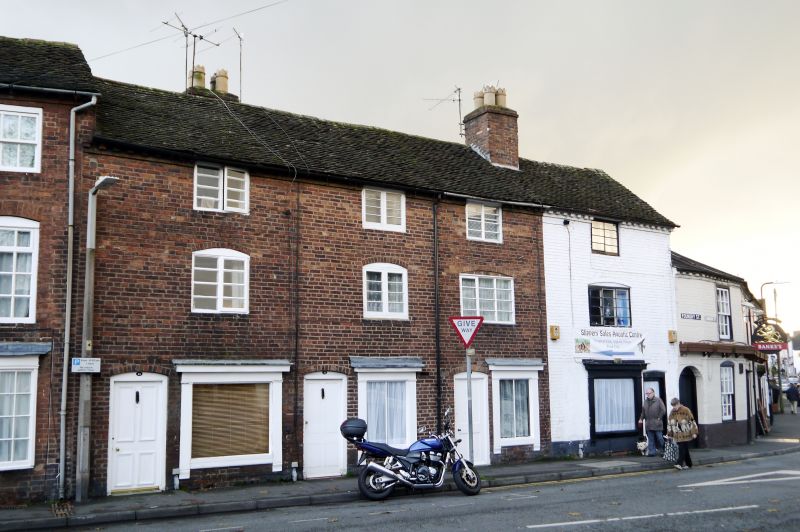
STOURPORT ON SEVERN
SO8171NW FOUNDRY STREET
589-1/5/21 (South East side)
18/05/76 Nos.15-18 (Consecutive)
GV II
Terrace of 4 houses, formerly including shops, one of which
remains. c1820. Brick with plain tiled roof. 3 storeyed, each
dwelling a single unit plan with 4-panelled doors and lower
windows with stressed wood architraves. Upper windows are
casements of 2 and 3-lights, with single ring segmentally
arched brick heads. Dentilled eaves band, axial stacks.
Listing NGR: SO8121171658
External links are from the relevant listing authority and, where applicable, Wikidata. Wikidata IDs may be related buildings as well as this specific building. If you want to add or update a link, you will need to do so by editing the Wikidata entry.


Other nearby listed buildings
