Latitude: 52.8068 / 52°48'24"N
Longitude: -2.1228 / 2°7'22"W
OS Eastings: 391817
OS Northings: 323257
OS Grid: SJ918232
Mapcode National: GBR 16X.43F
Mapcode Global: WHBDT.CQC3
Plus Code: 9C4VRV4G+PV
Entry Name: The Mill
Listing Date: 16 January 1951
Grade: II
Source: Historic England
Source ID: 1211205
English Heritage Legacy ID: 383943
ID on this website: 101211205
Location: Broadeye, Stafford, Staffordshire, ST16
County: Staffordshire
District: Stafford
Electoral Ward/Division: Forebridge
Parish: Non Civil Parish
Built-Up Area: Stafford
Traditional County: Staffordshire
Lieutenancy Area (Ceremonial County): Staffordshire
Church of England Parish: Stafford St Mary
Church of England Diocese: Lichfield
Tagged with: Tower mill
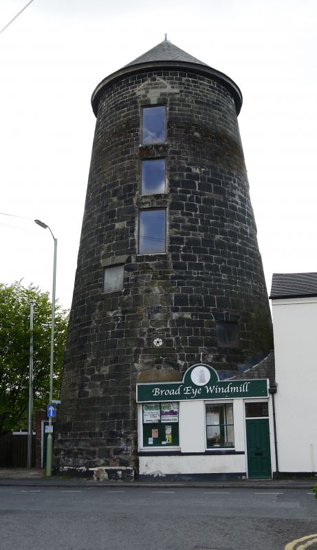
STAFFORD
SJ9123 CASTLE HILL
590-1/5/6 (West side)
16/01/51 The Mill
II
Tower windmill. 1796 using materials from demolished late C16
Shire Hall. Dressed stone. Conical tower, covered in
scaffolding at time of inspection. Blocked entrance recorded
as having Royal arms from Shire Hall above (not found); iron
roundel above has lettering: 1796/ MI. Windows, some blocked,
have wedge lintels with keys. Cap missing.
INTERIOR retains heavily moulded floor beams of substantial
scantling to each floor, possibly incorporated from demolition
of Elizabethan Shire Hall in 1793. Some heavy timbers and
trusses to conical roof remain. The mill was steam powered by
1847 and ceased working in early 1880s and was derelict by the
late 1930s. Although derelict, the mill is an important
landmark in Stafford The site is believed to be that of the
Norman Royal castle of c1070, and the mill is sometimes
claimed as standing on the foundations of the castle keep.
(Victoria County History of Staffordshire: Greenslade MW: A
History of Stafford, taken from VCH: London: 1979-: 200,
212-3).
Listing NGR: SJ9181723257
External links are from the relevant listing authority and, where applicable, Wikidata. Wikidata IDs may be related buildings as well as this specific building. If you want to add or update a link, you will need to do so by editing the Wikidata entry.


Other nearby listed buildings