Latitude: 51.5235 / 51°31'24"N
Longitude: -1.1447 / 1°8'41"W
OS Eastings: 459433
OS Northings: 180855
OS Grid: SU594808
Mapcode National: GBR 91Z.KD9
Mapcode Global: VHCYW.3YPZ
Plus Code: 9C3WGVF4+94
Entry Name: Sutton Tomb Approximately 10 Metres to South West of Tower of Church of St Mary
Listing Date: 29 November 1983
Grade: II
Source: Historic England
Source ID: 1213284
English Heritage Legacy ID: 397854
ID on this website: 101213284
Location: St Mary's Church, Streatley, West Berkshire, RG8
County: West Berkshire
Civil Parish: Streatley
Built-Up Area: Streatley
Traditional County: Berkshire
Lieutenancy Area (Ceremonial County): Berkshire
Tagged with: Tomb
STREATLEY HIGH STREET (north side)
SU 5980
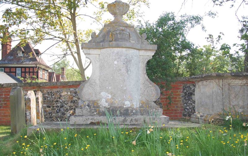
10/12 Sutton Tomb Approximately
10 Metres To South-west Of
Tower Of Church Of St. Mary
II
GV
Chest tomb. Early C19. Ashlar. Moulded base and scrolled top with crown
and urn finial. Oval plan. Large flanking scrolls to east and west.
Formerly railed. Inscription: To Samuel Sutton.
Listing NGR: SU5943380855
External links are from the relevant listing authority and, where applicable, Wikidata. Wikidata IDs may be related buildings as well as this specific building. If you want to add or update a link, you will need to do so by editing the Wikidata entry.


Other nearby listed buildings