Latitude: 54.0535 / 54°3'12"N
Longitude: -2.8051 / 2°48'18"W
OS Eastings: 347388
OS Northings: 462246
OS Grid: SD473622
Mapcode National: GBR 8PVK.HP
Mapcode Global: WH846.WCDW
Plus Code: 9C6V353V+9X
Entry Name: 21 and 22, St Georges Quay
Listing Date: 18 February 1970
Last Amended: 13 March 1995
Grade: II
Source: Historic England
Source ID: 1213377
English Heritage Legacy ID: 383297
ID on this website: 101213377
Location: Lancaster, Lancashire, LA1
County: Lancashire
District: Lancaster
Electoral Ward/Division: Castle
Parish: Non Civil Parish
Built-Up Area: Lancaster
Traditional County: Lancashire
Lieutenancy Area (Ceremonial County): Lancashire
Church of England Parish: Lancaster St Mary with St John and St Anne
Church of England Diocese: Blackburn
Tagged with: Building
LANCASTER
SD4762 ST GEORGE'S QUAY 1685-1/3/263 (South West side) 18/02/70 Nos.21 AND 22 (Formerly Listed as: ST GEORGE'S QUAY No.21) (Formerly Listed as: ST GEORGE'S QUAY No.22)
GV II
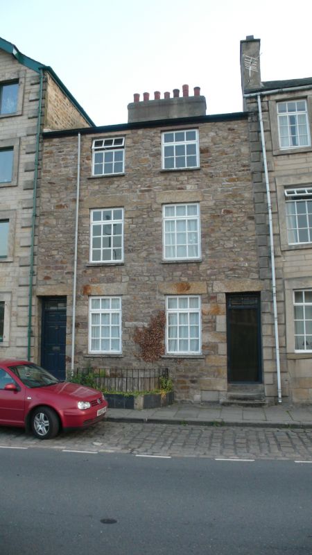
Pair of houses. c1800, altered C20. Sandstone rubble with slate roof. Double-depth plan. Symmetrical facade of 3 storeys above a cellar, with one bay to each house and with outer doorways. Windows have plain reveals and are late C20 casements with glazing bars. In front of the central cellar opening is a small area with iron railings. The doorways each have one reveal of hammer-dressed quoins and abut the chamfered quoins of the adjoining buildings, suggesting that the house is a later infill. The doorways both have transom lights. The left-hand door has 6 raised and fielded panels and the right-hand door has been replaced with glazing, both with overlights. Chimney on ridge parallel with front wall.
Listing NGR: SD4738762243
External links are from the relevant listing authority and, where applicable, Wikidata. Wikidata IDs may be related buildings as well as this specific building. If you want to add or update a link, you will need to do so by editing the Wikidata entry.


Other nearby listed buildings