Approximate Location Map
Large Map »
Latitude: 53.2796 / 53°16'46"N
Longitude: -1.7718 / 1°46'18"W
OS Eastings: 415313
OS Northings: 375875
OS Grid: SK153758
Mapcode National: GBR JZ2J.61
Mapcode Global: WHCCS.RTHM
Plus Code: 9C5W76HH+V7
Entry Name: 1-6, The Old School Close
Listing Date: 30 August 1984
Grade: II
Source: Historic England
Source ID: 1215823
English Heritage Legacy ID: 400362
ID on this website: 101215823
Location: Tideswell, Derbyshire Dales, Derbyshire, SK17
County: Derbyshire
District: Derbyshire Dales
Civil Parish: Tideswell
Built-Up Area: Tideswell
Traditional County: Derbyshire
Lieutenancy Area (Ceremonial County): Derbyshire
Church of England Parish: Tideswell St John the Baptist
Church of England Diocese: Derby
Tagged with: Architectural structure
This list entry was subject to a Minor Amendment on 24 May 2023 to update the name and address, and reformat the text to current standards
SK 1575
7/29
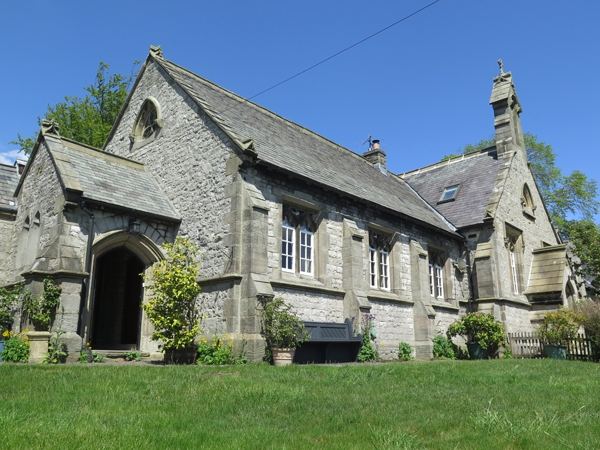
PARISH OF TIDESWELL
THE OLD SCHOOL CLOSE
1-6 (Consec)
(Formerly listed as Premises occupied by High Peak Plastics Ltd, ST JOHNS ROAD)
II
Former Church of England school, factory.(at time of listing) now converted into residential use. Late C19. Coursed squared rubble limestone with gritstone dressings. Flush quoins, coped gables, moulded kneelers, ashlar stacks with moulded caps and Welsh slated roofs. Irregular plan. South east elevation. Main range of ten bays, with entrance porch and lower two bay range with canted wall at south west end. Single storey, but with taller gabled windows and gabled ranges within the elevation, all rising from a chamfered plinth. Gabled range to north east end, with tall square headed mullioned and transomed windows, and a pointed arched traceried light above, beneath a hoodmould with carved stops. The next four bays have stepped buttresses, and two-light windows with mullions and ogee heads, those to the two centre bays with taller mullioned and transomed lights beneath gabled dormers. Advanced gabled central range with projecting single storey gabled porch, flanked by taller two-light ogee headed mullioned windows beneath flat hoodmoulds with stops. Traceried pointed arched opening within gable apex, and above a gabled bellcote. Remaining three bays with ogee headed two-light mullioned windows with buttresses between. Window sills and buttresses linked by continuous moulded stringcourse. Set back at south west end, a lower entrance porch with arched head to doorway, beneath a stilted hoodmould linked to a stringcourse. To the rear, a two bay extension with canted south west end.
Listing NGR: SK1531375875
External links are from the relevant listing authority and, where applicable, Wikidata. Wikidata IDs may be related buildings as well as this specific building. If you want to add or update a link, you will need to do so by editing the Wikidata entry.


Other nearby listed buildings
