Approximate Location Map
Large Map »
Latitude: 51.0002 / 51°0'0"N
Longitude: 0.4989 / 0°29'56"E
OS Eastings: 575438
OS Northings: 125285
OS Grid: TQ754252
Mapcode National: GBR PVH.6YR
Mapcode Global: FRA C6YG.L76
Plus Code: 9F322F2X+3H
Entry Name: Haiselman's Farmhouse
Listing Date: 13 May 1987
Grade: II
Source: Historic England
Source ID: 1217778
English Heritage Legacy ID: 412905
ID on this website: 101217778
Location: Rother, East Sussex, TN32
County: East Sussex
District: Rother
Civil Parish: Salehurst and Robertsbridge
Traditional County: Sussex
Lieutenancy Area (Ceremonial County): East Sussex
Church of England Parish: Salehurst St Mary
Church of England Diocese: Chichester
Tagged with: Farmhouse
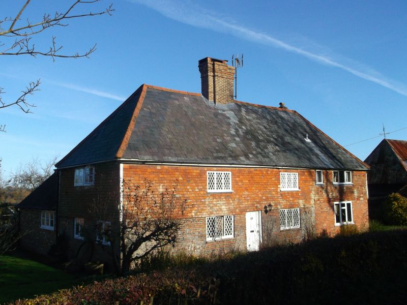
TQ 72 NE SALEHURST BOURNE LANE
6/10 Hasselsmans Farmhouse
II
Early C16 timber-framed building, refaced in the C18 with red brick on ground floor
and tile-hung above. Hipped slate roof. Casement windows. 2 storeys. 4 windows.
Listing NGR: TQ7543825285
External links are from the relevant listing authority and, where applicable, Wikidata. Wikidata IDs may be related buildings as well as this specific building. If you want to add or update a link, you will need to do so by editing the Wikidata entry.


Other nearby listed buildings
