Approximate Location Map
Large Map »
Latitude: 49.9283 / 49°55'41"N
Longitude: -6.293 / 6°17'34"W
OS Eastings: 92014
OS Northings: 11956
OS Grid: SV920119
Mapcode National: GBR BXVW.2BJ
Mapcode Global: VGYC4.W20B
Plus Code: 8CXMWPH4+8R
Entry Name: Borough Farmhouse
Listing Date: 14 December 1992
Grade: II
Source: Historic England
Source ID: 1218430
English Heritage Legacy ID: 62471
ID on this website: 101218430
Location: Maypole, Isles of Scilly, Cornwall, TR21
County: Isles of Scilly
Civil Parish: St. Mary's
Lieutenancy Area (Ceremonial County): Cornwall
Church of England Parish: Isles of Scilly
Church of England Diocese: Truro
Tagged with: Farmhouse
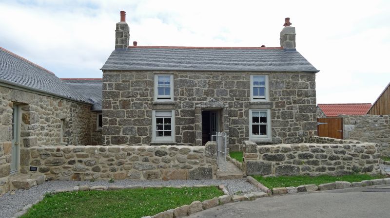
ST. MARY'S
SV91SW Borough Farmhouse
1358-0/4/33
II
Farmhouse. Late C18/early C19. Squared random coursed granite;
slurried Delabole slate roof; stone stacks. Double-depth plan.
2 storeys;3-bay, 2-window first-floor,range. Central granite
gabled porch with C20 door. Mid/late C19 horned 2/2-pane
sashes.Prominent gable end stacks Cl9 wing to left with pantile
roof. Interior not inspected.
Listing NGR: SV9201411956
External links are from the relevant listing authority and, where applicable, Wikidata. Wikidata IDs may be related buildings as well as this specific building. If you want to add or update a link, you will need to do so by editing the Wikidata entry.


Other nearby listed buildings
