Approximate Location Map
Large Map »
Latitude: 53.2776 / 53°16'39"N
Longitude: -2.1289 / 2°7'43"W
OS Eastings: 391502
OS Northings: 375637
OS Grid: SJ915756
Mapcode National: GBR FZKJ.WR
Mapcode Global: WHBBH.8WH5
Plus Code: 9C5V7VHC+3C
Entry Name: Oldhams Hollow Farmhouse
Listing Date: 17 March 1977
Grade: II
Source: Historic England
Source ID: 1220075
English Heritage Legacy ID: 391039
ID on this website: 101220075
Location: Tytherington, Cheshire East, Cheshire, SK10
County: Cheshire East
Civil Parish: Macclesfield
Built-Up Area: Macclesfield
Traditional County: Cheshire
Lieutenancy Area (Ceremonial County): Cheshire
Church of England Parish: St Michael and All Angels, Macclesfield
Church of England Diocese: Chester
Tagged with: Farmhouse
MACCLESFIELD
SJ97NW MANCHESTER ROAD, Tytherington
886-1/2/216 (West side)
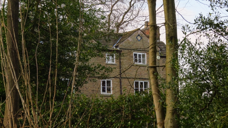
17/03/77 Oldham's Hollow Farmhouse
II
Farmhouse. Late C17. Coursed and squared rubble with
stone-flagged roof and substantial internal timber frame.
3-storeyed, 3-window range with central entrance hall.
EXTERIOR: doorway in ovolo-moulded architrave flanked by
3-light wood mullioned window on each floor, the stone
architraves all that remains of former stone mullioned
windows. Smaller 2-light mullioned windows on each floor over
the doorway. Various blocked openings to right and left on
each floor. String courses above each storey. Shallow gables
form dormers to attic storey windows, with lozenge panels at
apex. Parallel rear range with large wood mullioned windows
lighting stairs. Gable end and axial stacks.
INTERIOR contains substantial quantities of timber-framing for
internal walls, with chamfered beams to ceilings and fireplace
bressumers. Late C17 staircase with twisted balusters and
moulded rail.
Listing NGR: SJ9150275637
External links are from the relevant listing authority and, where applicable, Wikidata. Wikidata IDs may be related buildings as well as this specific building. If you want to add or update a link, you will need to do so by editing the Wikidata entry.


Other nearby listed buildings
