Latitude: 54.0498 / 54°2'59"N
Longitude: -2.8041 / 2°48'14"W
OS Eastings: 347453
OS Northings: 461834
OS Grid: SD474618
Mapcode National: GBR 8PVM.Q0
Mapcode Global: WH846.WGXQ
Plus Code: 9C6V25XW+W9
Entry Name: 6-12, Castle Hill
Listing Date: 18 February 1970
Last Amended: 13 March 1995
Grade: II
Source: Historic England
Source ID: 1220695
English Heritage Legacy ID: 383066
ID on this website: 101220695
Location: Lancaster, Lancashire, LA1
County: Lancashire
District: Lancaster
Electoral Ward/Division: Castle
Parish: Non Civil Parish
Built-Up Area: Lancaster
Traditional County: Lancashire
Lieutenancy Area (Ceremonial County): Lancashire
Church of England Parish: Lancaster St Mary with St John and St Anne
Church of England Diocese: Blackburn
Tagged with: Building Warehouse Office building Cottage
LANCASTER
SD4761NW CASTLE HILL 1685-1/6/32 (West side) 18/02/70 Nos.6-12 (Even) Witchways (Formerly Listed as: CASTLE HILL (North West side) Nos.4, 6 AND 8)
GV II
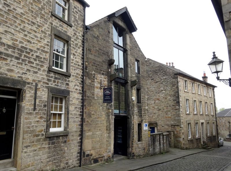
Marked on OS as Nos 4, 6 & 8. Row of 3 cottages and attached former warehouse, now office. Cottages early C19, with C20 alterations. Warehouse mid C18, remodelled in late C19, and altered C20. Squared sandstone with ashlar dressings. Cottages have stone slate roof with gable chimneys, and warehouse has composition tile roof. The cottages have quoins above the level of the warehouse eaves and square stone gutter brackets. Double-depth plan. Each cottage has 3 storeys and a single bay, the one to No.12 being canted back on the left. The windows and doorways have plain surrounds and late C20 joinery. The doorways of Nos 8 & 10 are coupled and placed between the windows. No.12 has a door to the left with a window to its left. The door is set into the gable wall of Nos 21-29 St Mary's Parade (qv) which adjoins at right angles and has its ground floor at a higher level because of the slope of the ground. In 1988 a well, which presumably antedates the cottages, was found immediately next to the rear wall of the cottages. No.6, the former warehouse, is of 2-unit plan, with the gable to the road. 3 storeys and attic, with a central 4-stage loading slot (now glazed) whose jambs and head have ovolo chamfers, and small internal corbels to support loading platforms. On the second floor there are larger external corbels, with a bracket for a crane just above on the left. To the right is a later doorway and 2 original stair windows vertically aligned above it; to the left on the first floor is an inserted window. The left corner has quoins, but the right-hand corner is tusked. The rear gable, built into higher ground, has only 2 storeys, with a 2-stage loading slot, where each doorway has a massive stone lintel, the lower one flanked by stone corbels. In the apex of the gable are 3 pigeon holes with perching ledges, protected by the projecting verge of the top of the roof. INTERIOR: a newel staircase (now blocked), remains of a former doorway in the right-hand wall, and of fireplaces in the left wall. Large pine beams, chamfered with run-out stops. On the first floor, remains of elaborate moulded plasterwork, presumably surviving from a former use as a plasterer's workshop.
Listing NGR: SD4745161834
External links are from the relevant listing authority and, where applicable, Wikidata. Wikidata IDs may be related buildings as well as this specific building. If you want to add or update a link, you will need to do so by editing the Wikidata entry.


Other nearby listed buildings