Approximate Location Map
Large Map »
Latitude: 50.8092 / 50°48'33"N
Longitude: -2.7369 / 2°44'12"W
OS Eastings: 348173
OS Northings: 101333
OS Grid: ST481013
Mapcode National: GBR MJ.YBFZ
Mapcode Global: FRA 564Y.RJZ
Plus Code: 9C2VR757+M6
Entry Name: Nos 12 and 14 and Attached Rubble Stone Wall
Listing Date: 12 June 1953
Grade: II
Source: Historic England
Source ID: 1220914
English Heritage Legacy ID: 394599
ID on this website: 101220914
Location: Beaminster, Dorset, DT8
County: Dorset
Civil Parish: Beaminster
Built-Up Area: Beaminster
Traditional County: Dorset
Lieutenancy Area (Ceremonial County): Dorset
Church of England Parish: Beaminster St Mary of the Annunciation
Church of England Diocese: Salisbury
Tagged with: Building
BEAMINSTER NORTH STREET
ST 4701/4801
12-6-53 ( SOUTH SIDE )
7/116 Nos 12 and 14, and
attached rubble-stone
wall
GV II
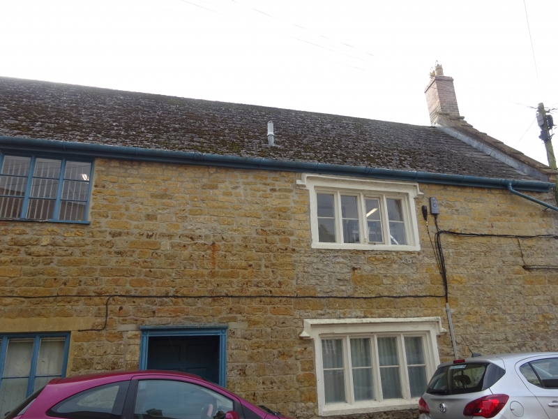
Detached House, formerly two. C17, with C18 and later fenestration.
Lias stone walls. Asbestos slate roof with stone gable copings. Renewed
brick stacks at left and right gables. Right hand projecting stack with
2 set-offs. 2 storeys. 3 windows, right hand side: 2 4-light stone
mullions with hollow chamfers. Returned labels over. Colour washed.
C17. Left hand: 2 sashes with glazing-bars, renewed. Centre: C20 3-
light casements. Front doors: left and right of centre, C19. Both 6-panelled
with panelled reveals and reeded surround. West gable wall: 2 2-light
mullions with hollow chamfers and labels. One single-light attic window
with moulded stone frame and label.
Attached rubble-stone wall with string and rubble coping for 25 metres
along lane and returns for 30 metres up towards no 16.
Source: R.C.H.M. Dorset I, p 25(39).
Listing NGR: ST4817601336
External links are from the relevant listing authority and, where applicable, Wikidata. Wikidata IDs may be related buildings as well as this specific building. If you want to add or update a link, you will need to do so by editing the Wikidata entry.


Other nearby listed buildings
