Approximate Location Map
Large Map »
Latitude: 51.807 / 51°48'25"N
Longitude: -1.6367 / 1°38'11"W
OS Eastings: 425147
OS Northings: 212106
OS Grid: SP251121
Mapcode National: GBR 5SW.M1K
Mapcode Global: VHBZS.LV33
Plus Code: 9C3WR947+R8
Entry Name: The Highway Hotel
Listing Date: 12 September 1955
Grade: II*
Source: Historic England
Source ID: 1224038
English Heritage Legacy ID: 419988
ID on this website: 101224038
Location: Burford, West Oxfordshire, OX18
County: Oxfordshire
District: West Oxfordshire
Civil Parish: Burford
Built-Up Area: Burford
Traditional County: Oxfordshire
Lieutenancy Area (Ceremonial County): Oxfordshire
Church of England Parish: Burford
Church of England Diocese: Oxford
Tagged with: Hotel
BURFORD AND UPTON HIGH STREET
AND SIGNET (East Side)
SP2512 (Enlargement) No 117 (The Highway
7/88 Hotel)
12.9.55
GV II*
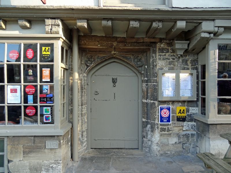
House and hostelry. C15 or C16, altered C18, 2nd floor said to be by a
Mr Horniman in 1922. Render on timber-frame, Cotswold stone roof. 3
storeys; upper two jettied. 4 paired glazing-bar sash windows on 2nd
floor, 2 glazing-bar sashes and 2 outer angled bays with glazing bar
sashes to 1st floor, oval window to right hand of 1st floor. Wine
underbuilt rectangular bays with glazing-bar sash windows on ground floor;
doors, to left C16 moulded timber surround with urn stops and 2 fire
insurance plates (Farmers and County); to right tall stone moulded Tudor
archway with traceried spandrels.
Listing NGR: SP2514712106
External links are from the relevant listing authority and, where applicable, Wikidata. Wikidata IDs may be related buildings as well as this specific building. If you want to add or update a link, you will need to do so by editing the Wikidata entry.


Other nearby listed buildings
