Approximate Location Map
Large Map »
Latitude: 51.8088 / 51°48'31"N
Longitude: -1.6365 / 1°38'11"W
OS Eastings: 425158
OS Northings: 212305
OS Grid: SP251123
Mapcode National: GBR 5SW.F34
Mapcode Global: VHBZS.LS6Q
Plus Code: 9C3WR957+GC
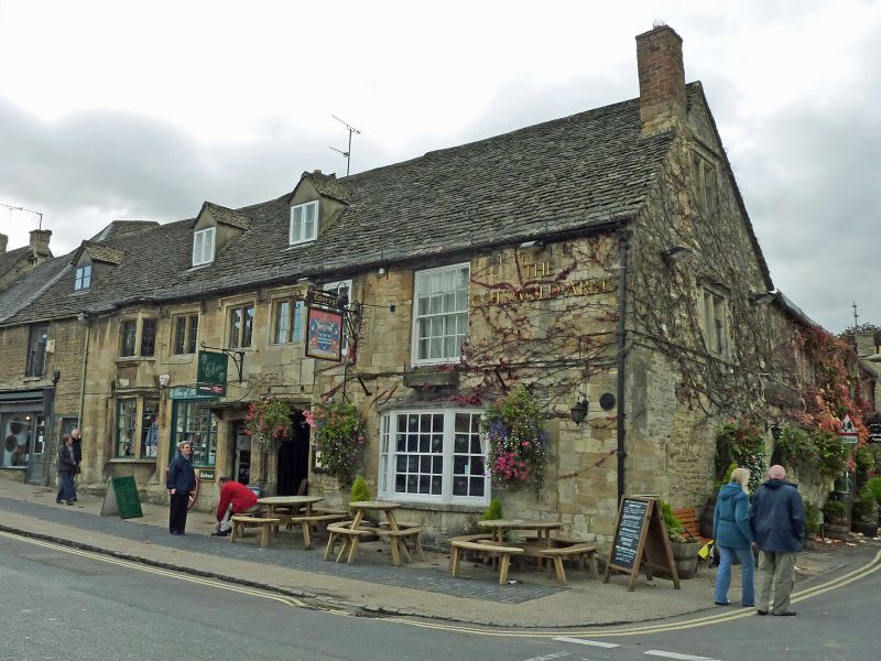
Entry Name: The Cotswold Arms Inn
Listing Date: 12 September 1955
Grade: II
Source: Historic England
Source ID: 1224324
English Heritage Legacy ID: 420352
Also known as: The Cotswold Arms, Burford
Cotswold Arms
ID on this website: 101224324
Location: Burford, West Oxfordshire, OX18
County: Oxfordshire
District: West Oxfordshire
Civil Parish: Burford
Built-Up Area: Burford
Traditional County: Oxfordshire
Lieutenancy Area (Ceremonial County): Oxfordshire
Church of England Parish: Burford
Church of England Diocese: Oxford
BURFORD AND UPTON HIGH STREET
AND SIGNET (West Side)
SP2512 (Enlargement) The Cotswold Arms Inn Cotswold Arms Inn
7/123
12.9.55
GV II
Inn, perhaps historically so. Late mediaeval and late 17th century, but
front remodelled early-mid C19. Irregular rubble with Cotswold stone roof
- L-plan. Built originally as one with premises to North (q.v.) 2
storeys. 2 windows, glazing-bar sashes, one in centre of 1st floor, the
left hand one has timber lintel, angled glazing below also with glazing-
bar sashes. Good Tudor arch doorway to left (actually under the right
hand window of adjacent premises to South (q.v. under Caroline Jane) ; deep
moulded surround with enriched spandrels. Good early-mid C19 Gothick door
with bowtel mouldings to tracery. Evidence of blocked mullion window on
1st floor to right. Gabled return, to Priory Lane, has mullioned windows ;
2 storeys and attic with 2-light mullion windows to attic and 1st floor,
and plain doorway to right. 2-storey extension with 1:3 windows, to left
mullioned with drips, 5-light on ground floor, to right mid-C19 sashes,
ground floor altered. Further lower extension has 3-bay roof structure,
part-restored, with braces, perhaps a C16 cottage converted to stable use.
Interior: altered; rear extension has wide elliptical-headed fire-place
on ground floor, partly blocked.
Listing NGR: SP2515812305
External links are from the relevant listing authority and, where applicable, Wikidata. Wikidata IDs may be related buildings as well as this specific building. If you want to add or update a link, you will need to do so by editing the Wikidata entry.


Other nearby listed buildings
