Approximate Location Map
Large Map »
Latitude: 52.8256 / 52°49'32"N
Longitude: -1.2554 / 1°15'19"W
OS Eastings: 450269
OS Northings: 325603
OS Grid: SK502256
Mapcode National: GBR 8JZ.TP1
Mapcode Global: WHDHH.P7DN
Plus Code: 9C4WRPGV+6R
Entry Name: 1, Soar Lane
Listing Date: 13 October 1966
Grade: II
Source: Historic England
Source ID: 1242375
English Heritage Legacy ID: 441776
ID on this website: 101242375
Location: Sutton Bonington, Rushcliffe, Nottinghamshire, LE12
County: Nottinghamshire
District: Rushcliffe
Civil Parish: Sutton Bonington
Traditional County: Nottinghamshire
Lieutenancy Area (Ceremonial County): Nottinghamshire
Church of England Parish: Sutton Bonington
Church of England Diocese: Southwell and Nottingham
Tagged with: Building
This list entry was subject to a Minor Amendment on 06/06/2014
SK 52 NW
4/111
SUTTON BONINGTON,
SOAR LANE (west side),
No. 1
13.10.66
G.V. II
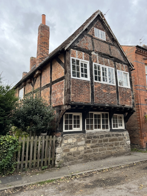
House. amid C17 with C18 and C19 alterations. Timber framed with red brick nogging, in the main herringbone. Some rubble and render. Plain tile roof. External C20 red brick and render stack to rear gable and single red brick stack to left. Deep rubble plinth. Gable end to road of 2 storeys plus garret with first floor jetty, 3 bays. Small framing. Single tripartite glazing bar Yorkshire sash flanked by single similar 2 light sashes. Above are 3 similar sashes with single small glazing bar casement in the garret. Bressumer dated "1661". The left/south front with similar framing to the majority/right bays and larger framing to the left. Single casement with some glazing bars and to the left a single glazing bar Yorkshire sash. Above is a single casement with some glazing bars. Attached to the left is a rendered lean-to. First floor windows said to be inserted to light a framework knitter's workshop. Smith, David. Industrial Archaeology of the East Midlands.
Listing NGR: SK5026925603
External links are from the relevant listing authority and, where applicable, Wikidata. Wikidata IDs may be related buildings as well as this specific building. If you want to add or update a link, you will need to do so by editing the Wikidata entry.


Other nearby listed buildings
