Latitude: 52.2491 / 52°14'56"N
Longitude: 0.7121 / 0°42'43"E
OS Eastings: 585236
OS Northings: 264677
OS Grid: TL852646
Mapcode National: GBR QDT.T12
Mapcode Global: VHKD4.9Q9Q
Plus Code: 9F426PX6+JR
Entry Name: 33, St Johns Street
Listing Date: 12 July 1972
Grade: II
Source: Historic England
Source ID: 1244965
English Heritage Legacy ID: 467190
ID on this website: 101244965
Location: Bury St Edmunds, West Suffolk, IP33
County: Suffolk
District: West Suffolk
Civil Parish: Bury St Edmunds
Built-Up Area: Bury St Edmunds
Traditional County: Suffolk
Lieutenancy Area (Ceremonial County): Suffolk
Church of England Parish: Bury St Edmunds St John the Evangelist
Church of England Diocese: St.Edmundsbury and Ipswich
Tagged with: House
BURY ST EDMUNDS
TL8564NW ST JOHN'S STREET 639-1/3/603 (West side) 12/07/72 No.33
II
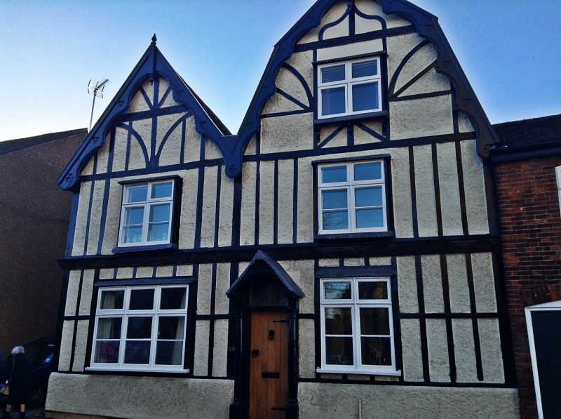
House, now divided into 3 flats. C17 core with C18 and early C20 extensions. Part timber-framed, part brick; pebbledash exterior with mock timbering; plaintiled roof with 2 gables facing the street, that on the right a mansard. EXTERIOR: 2 storeys and attics. One projecting cross window in the mansard gable supported by 3 ornate brackets; 2 slightly projecting cross windows to the upper storey; a 3-light window on left and one cross window on right on the ground storey, both in heavy flush frames. A small open gabled porch roof over the central doorway supported on timber columns. Plank door. Above the ground storey a timber band, elaborately carved with a vine motif, dated 1630 with a shield bearing a chevron and 33 woolsacks. This was originally a fascia board covering a jetty and is not in situ. At tie-beam and collar level on the gables are bands of Jacobean ornament, also not in situ. The Victorian pierced and fluted bargeboards to the gables are also re-used. INTERIOR: the right side of the house has a fragmentary C17 core, with the line of the lower wallplate and tie visible in the upper room; it was raised and given a mansard roof in the C18. The left side seems to be an extension of the same date as the facade, and is quite without decoration or features of interest inside.
Listing NGR: TL8523664677
External links are from the relevant listing authority and, where applicable, Wikidata. Wikidata IDs may be related buildings as well as this specific building. If you want to add or update a link, you will need to do so by editing the Wikidata entry.


Other nearby listed buildings