Latitude: 53.8013 / 53°48'4"N
Longitude: -2.2375 / 2°14'15"W
OS Eastings: 384453
OS Northings: 433915
OS Grid: SD844339
Mapcode National: GBR DSTH.C2
Mapcode Global: WHB7X.LQQ6
Plus Code: 9C5VRQ26+GX
Entry Name: Jamia Mosque Farooq-E-Azam with Attached Boundary Wall and Railings
Listing Date: 19 November 1997
Grade: II
Source: Historic England
Source ID: 1244992
English Heritage Legacy ID: 467153
ID on this website: 101244992
Location: Burnley Lane, Burnley, Lancashire, BB10
County: Lancashire
District: Burnley
Electoral Ward/Division: Daneshouse with Stoneyholme
Parish: Non Civil Parish
Built-Up Area: Burnley
Traditional County: Lancashire
Lieutenancy Area (Ceremonial County): Lancashire
Church of England Parish: Burnley St Andrew with St Margaret
Church of England Diocese: Blackburn
Tagged with: Building
BURNLEY
SD83SW NORTH STREET 906-1/3/104 (East side) Jamia Mosque Farooq-E-Azam, with attached boundary wall and railings
GV II
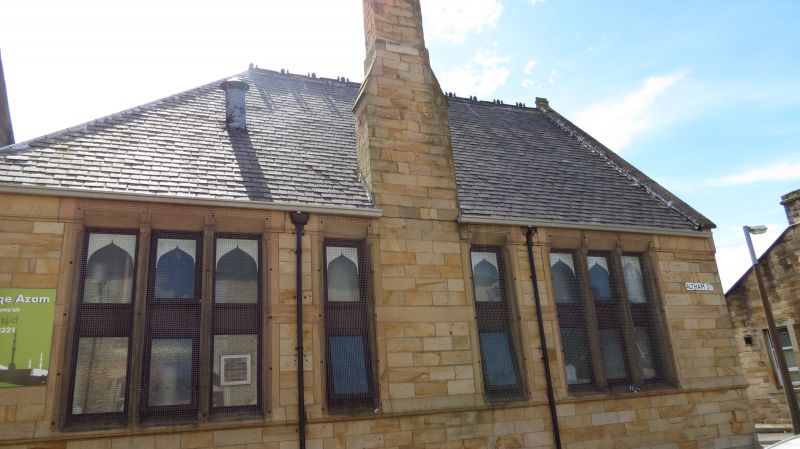
Baptist Sunday and day school with attached boundary wall and railings, now mosque. 1878, altered. Sandstone ashlar, slate roofs. C17 Vernacular style. PLAN: E-plan formed by a main hall-range fronting North Street with receding wings at both ends and in the centre of the rear, the left wing coupled with a porch at the left end of the main range. EXTERIOR: single-storey, 2:1:6:1 windows, the wings and porch taller than the main range; with a chamfered plinth, swept and moulded sillband. The hall-range has 2-light mullioned windows with chamfered surrounds and mullions; to the left, the taller gabled porch, breaking the eaves, has an altered doorway with tall mullioned overlight, and the gable of the wing to its left has 2 tall 2-light windows, these 3 openings linked by a deep hood-mould stepped over them, with foliated terminal stops. The gable of the right-hand wing has one tall 3-light window in similar style. Each wing also has a small 2-light window in the gable, and all 3 gables are steeply-pitched, with stone copings. The left return of the left wing (to Altham Street) has windows of 2, 1, 1 and 2 lights symmetrically disposed either side of a side-wall chimney; the right return of the right-hand wing has 2 large 3-light windows with deep hood-moulds finished with foliated stops. INTERIOR not inspected. SUBSIDIARY FEATURES: attached to the right-hand corner is a low wall with chamfered coping which carries cast-iron spear railings and columnar standards with urn finials, and has a gate at the left end in similar style but with an arched top-rail. The wall and railings have an eastward return along Angle Street, ramping up to meet a short section of higher boundary wall at the junction with the boundary of Angle Street Baptist Chapel (qv). Forms a good group with the parent chapel, sharing a small triangular plot with it.
Listing NGR: SD8445333915
External links are from the relevant listing authority and, where applicable, Wikidata. Wikidata IDs may be related buildings as well as this specific building. If you want to add or update a link, you will need to do so by editing the Wikidata entry.


Other nearby listed buildings