Approximate Location Map
Large Map »
Latitude: 52.2427 / 52°14'33"N
Longitude: 0.7112 / 0°42'40"E
OS Eastings: 585200
OS Northings: 263960
OS Grid: TL852639
Mapcode National: GBR QF0.6NR
Mapcode Global: VHKD4.8WTN
Plus Code: 9F426PV6+3F
Entry Name: 31 and 32, St Andrews Street South
Listing Date: 12 July 1972
Grade: II
Source: Historic England
Source ID: 1245000
English Heritage Legacy ID: 467161
ID on this website: 101245000
Location: Bury St Edmunds, West Suffolk, IP33
County: Suffolk
District: West Suffolk
Civil Parish: Bury St Edmunds
Built-Up Area: Bury St Edmunds
Traditional County: Suffolk
Lieutenancy Area (Ceremonial County): Suffolk
Church of England Parish: Bury St Edmunds St Mary
Church of England Diocese: St.Edmundsbury and Ipswich
Tagged with: Building
BURY ST EDMUNDS
TL8563NW ST ANDREW'S STREET SOUTH
639-1/10/591 (West side)
12/07/72 Nos.31 AND 32
GV II
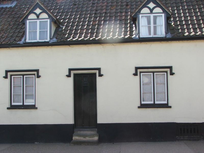
House, later a pair of cottages, No.32 now an office. Early to
mid C19 front, late C17/early C18 core. Timber-framed and
rendered; pantiled roofs.
EXTERIOR: single storey and attics; cellar. 3 window range:
2-light casements with horizontal glazing bars and wooden
hood-moulds. 2 doorways, approached by steps, have Gothic
panelled doors and wooden hood-moulds; a carriageway at the
south end has similar panelled double doors and hood-mould. 4
gabled dormers with mock timbering in the apex have 2-light
single bar casement windows and fluted bargeboards. A central
square chimney-stack.
INTERIOR: No.31 (not inspected) is said to have no exposed
timbering or original features visible. No.32 has a cellar
with mixed walling of flint, old brick and some clunch; some
C17 roof timbers. Little exposed timbering inside, but some
C18 framing. The 2 cottages are divided on the line of an
internal chimney-stack. Roof, partly in soft-wood, has clasped
purlins, saddles linking the tops of the rafters and a
ridge-piece to part.
Listing NGR: TL8520063960
External links are from the relevant listing authority and, where applicable, Wikidata. Wikidata IDs may be related buildings as well as this specific building. If you want to add or update a link, you will need to do so by editing the Wikidata entry.


Other nearby listed buildings
