Approximate Location Map
Large Map »
Latitude: 53.1854 / 53°11'7"N
Longitude: -2.8929 / 2°53'34"W
OS Eastings: 340430
OS Northings: 365741
OS Grid: SJ404657
Mapcode National: GBR 79.3CSW
Mapcode Global: WH88F.J6NB
Plus Code: 9C5V54P4+5R
Entry Name: Curtain Wall to West and South West of Inner Bailey
Listing Date: 1 June 1967
Last Amended: 26 February 1985
Grade: I
Source: Historic England
Source ID: 1245537
English Heritage Legacy ID: 452991
ID on this website: 101245537
Location: Chester, Cheshire West and Chester, Cheshire, CH1
County: Cheshire West and Chester
Civil Parish: Chester Castle
Built-Up Area: Chester
Traditional County: Cheshire
Lieutenancy Area (Ceremonial County): Cheshire
Church of England Parish: Chester St John the Baptist
Church of England Diocese: Chester
Tagged with: Wall
SJ 4065 NW
4/611
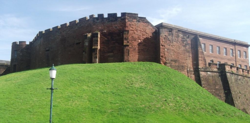
CHESTER CASTLE,
INNER BAILEY
Curtain Wall to west and south-west of Inner Bailey
(formerly listed as Curtain Wall, earlier remains including Sallyport and Halfmoon Tower)
1.6.67
GV I
Curtain wall. After 1246 with C18, C19 and C20 additions and alterations. Bunter sandstone ashlar. Forming western side of a rectangular enclosure with a rounded corner to the south-west. Set on Saxon defensive mound at west. Western front: Half-moon tower at extreme left; semicircular in plan with battered lower level. C19 sash windows to ground and first floors facing north and east. Battlemented parapet above. Low wall extending to left linking up with the rear of B Block (q.v.). To the right the curtain wall extends with a battlemented parapet and 2 early C19 horizontal gun slits. At the south-western curved corner are a series of three buttresses with offsets. Blocked door to ground floor level between second and third of these from left. Tower to right. Slightly projecting. The height of the wall diminishes via an offset at right of this tower but the wall extends considerably lower as the earth mound dies. Arched doorway to right approached by flight of C20 concrete steps leading to sallyport steps. Southern curtain wall of 1786 adjoins to right (q.v.). Rear: Arched sally port stairway exists at left with stairway up to ramparts immediately to right of it. Brick inner face of wall at right of this with stone walkway to ramparts with C20 iron railings. Flag tower projects at centre: two storeys of Bunter sandstone with central ground floor doorway and two openings to first floor, that at left with round arch, that at right with cement lintel. To right is projecting early C19 house on the site of the Frobisher's workshop and abutting the rear of the half-moon tower. Now of three bays, though originally extending further left. Entrance front: stucco rendered on three bays. Horned sash windows to first floor with stone cills. Lateral ground floor doors with central bowed oriel of 4 x 4 horned sash panes. Jagged wall at left indicating recent demolition.
Source:
Frank Simpson - "Chester Castle AD 907-1925". Journal of the Architectural, Archaeological and Historic Society, Chester and North Wales. New Series Vol.XXVI, Part II.
Listing NGR: SJ4042865717
External links are from the relevant listing authority and, where applicable, Wikidata. Wikidata IDs may be related buildings as well as this specific building. If you want to add or update a link, you will need to do so by editing the Wikidata entry.


Other nearby listed buildings
