Approximate Location Map
Large Map »
Latitude: 52.9695 / 52°58'10"N
Longitude: -1.1607 / 1°9'38"W
OS Eastings: 456463
OS Northings: 341678
OS Grid: SK564416
Mapcode National: GBR LLH.SN
Mapcode Global: WHDGS.4MKC
Plus Code: 9C4WXR9Q+QP
Entry Name: 89 to 95, Foxhall Road
Listing Date: 19 August 1988
Grade: II
Source: Historic England
Source ID: 1247600
English Heritage Legacy ID: 457122
ID on this website: 101247600
Location: Sherwood Rise, Nottingham, Nottinghamshire, NG7
County: City of Nottingham
Electoral Ward/Division: Berridge
Parish: Non Civil Parish
Built-Up Area: Nottingham
Traditional County: Nottinghamshire
Lieutenancy Area (Ceremonial County): Nottinghamshire
Church of England Parish: Hyson Green and Forest Fields
Church of England Diocese: Southwell and Nottingham
Tagged with: Building
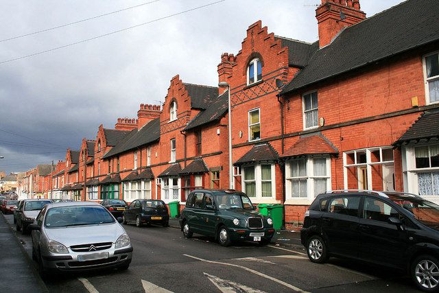
NOTTINGHAM
SK54SE FOXHALL ROAD
646-1/4/217 (East side)
19/08/88 Nos.89-95 (Odd)
GV II
Terrace of 4 houses. 1901. By Watson Fothergill of Nottingham
for Mr Willatt. Red brick, with blue brick and ashlar
dressings and plain tile roofs with 2 large ridge stacks.
Plinth and first floor sill band. 2 storeys plus attics; 4
window range. Windows are mainly original plain sashes.
Half-glazed doors with outer frames and overlights, 3 of them
renewed.
Symmetrical front, with higher end bays under crowstepped
gables. In the centre, a pair of doors under a brick segmental
arch. On either side, a pair of canted bay windows with hipped
roofs, then single doors with ashlar lintels. Above, 4
windows. Above again, in the gables, a round-arched opening
with a pair of plain sashes. Below the windows, a blue brick
diaper work band.
(Get to know Nottingham: Brand K: Watson Fothergill,
Architect: Nottingham: 1987-: 17).
Listing NGR: SK5646341678
External links are from the relevant listing authority and, where applicable, Wikidata. Wikidata IDs may be related buildings as well as this specific building. If you want to add or update a link, you will need to do so by editing the Wikidata entry.


Other nearby listed buildings
