Approximate Location Map
Large Map »
Latitude: 52.2434 / 52°14'36"N
Longitude: 0.7139 / 0°42'49"E
OS Eastings: 585380
OS Northings: 264052
OS Grid: TL853640
Mapcode National: GBR QF0.79H
Mapcode Global: VHKD4.BW72
Plus Code: 9F426PV7+9G
Entry Name: 16 and 17, Churchgate Street
Listing Date: 12 July 1972
Grade: II
Source: Historic England
Source ID: 1248114
English Heritage Legacy ID: 466703
ID on this website: 101248114
Location: Bury St Edmunds, West Suffolk, IP33
County: Suffolk
District: West Suffolk
Civil Parish: Bury St Edmunds
Built-Up Area: Bury St Edmunds
Traditional County: Suffolk
Lieutenancy Area (Ceremonial County): Suffolk
Church of England Parish: Bury St Edmunds St Mary
Church of England Diocese: St.Edmundsbury and Ipswich
Tagged with: Building
BURY ST EDMUNDS
TL8564SW CHURCHGATE STREET
639-1/14/236 (North side)
12/07/72 Nos.16 AND 17
GV II
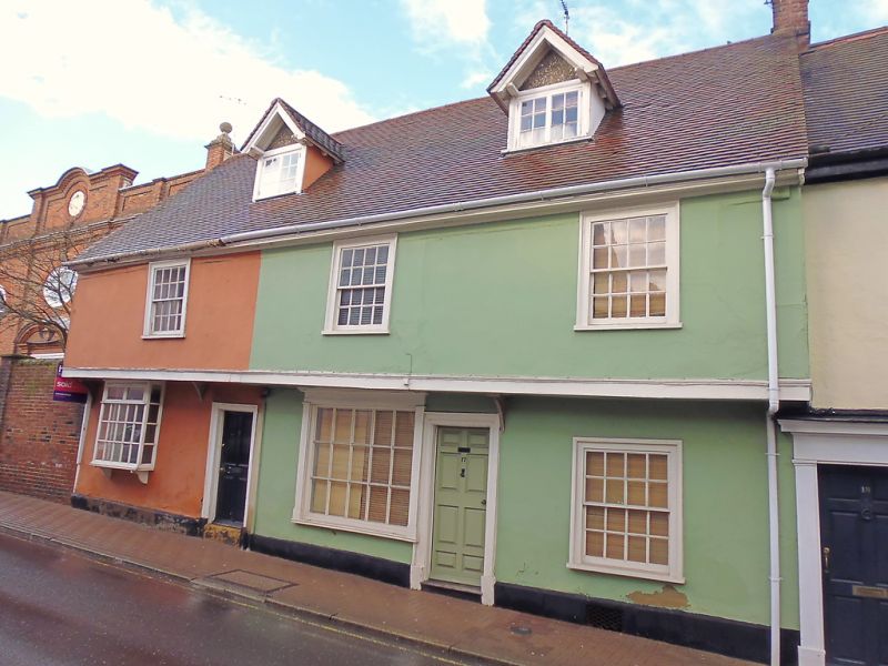
House, divided into 2. C16, altered in the C18 and C19.
Timber-framed and rendered with jettied front; plaintiled
roof.
EXTERIOR: 2 storeys and attics. 3 window range: 16-pane sashes
in cased frames. The ground storey has an C18 bay with a
moulded sill supported on plain curved brackets and an early
C19 shop window with moulded pilasters and cornice, both with
fixed 15-pane windows. 2 C20 gabled dormers with projecting
eaves and 2-light small-paned casement windows. Solid arched
brackets support the jettied front, which was widened to allow
for the insertion of the later sash windows. 2 doorways with
moulded surrounds: 4-panelled half-glazed door to No.16, and 8
sunk panels to No.17.
INTERIOR: this was a single 3-cell 4-bay house, divided into 2
in the early C19 by stud partitions: No.16 now contains
one-and-a-half bays and No.17 the remainder. The original
framing is plain and substantial: main beams, posts,
wallplates and some studding are exposed. Both end bays were
partitioned off, leaving a 2-bay single-storey hall in the
centre heated by a chimney-stack on the rear wall. The main
cross-beams are plain and heavy with a chamfer and curved
stepped stops.
On the upper storey of No.17 widely spaced studding and
tension bracing are exposed along one partition wall; in the
front wallplate, a slightly splayed edge-halved and bridled
scarf joint. Long jowls to the main posts. Unusually, both end
bays have evidence for a former division into 2, with a row of
mortices in the soffit of each main beam.
In No.17 the sawn-off tenons of the partition studs are still
in situ, whereas in No.16 there are no associated peg-holes or
tenons, and the partition may never have been completed.
Roof-timbers mainly concealed; roof-structure of a side-purlin
type, probably clasped.
This is one of several buildings in the town where the jetty
has been widened to allow for Georgian sashes to be inserted:
cf. Nos 25 & 26 (qv) for similar treatment.
Listing NGR: TL8538064052
External links are from the relevant listing authority and, where applicable, Wikidata. Wikidata IDs may be related buildings as well as this specific building. If you want to add or update a link, you will need to do so by editing the Wikidata entry.


Other nearby listed buildings
