Approximate Location Map
Large Map »
Latitude: 52.2432 / 52°14'35"N
Longitude: 0.7139 / 0°42'50"E
OS Eastings: 585384
OS Northings: 264032
OS Grid: TL853640
Mapcode National: GBR QF0.7BN
Mapcode Global: VHKD4.BW86
Plus Code: 9F426PV7+7H
Entry Name: 53 and 54, Churchgate Street
Listing Date: 12 July 1972
Grade: II
Source: Historic England
Source ID: 1248216
English Heritage Legacy ID: 466724
ID on this website: 101248216
Location: Bury St Edmunds, West Suffolk, IP33
County: Suffolk
District: West Suffolk
Civil Parish: Bury St Edmunds
Built-Up Area: Bury St Edmunds
Traditional County: Suffolk
Lieutenancy Area (Ceremonial County): Suffolk
Church of England Parish: Bury St Edmunds St Mary
Church of England Diocese: St.Edmundsbury and Ipswich
Tagged with: Building
BURY ST EDMUNDS
TL8554SW CHURCHGATE STREET
639-1/14/257 (South side)
12/07/72 Nos.53 AND 54
GV II
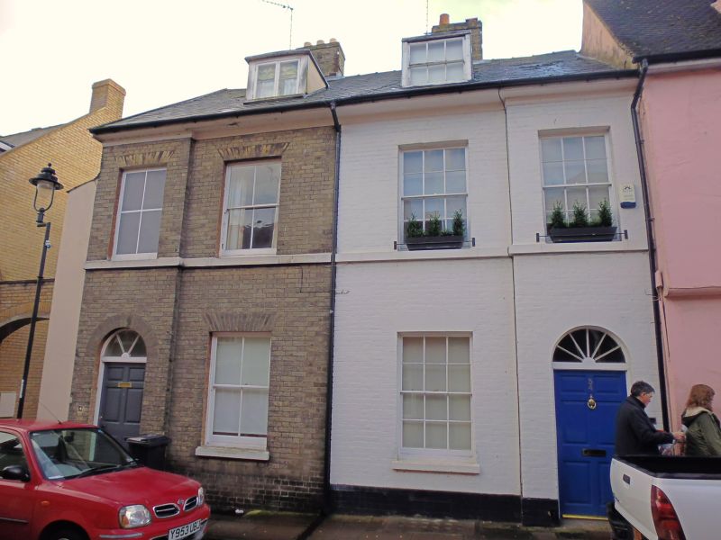
A pair of semi-detached houses. Early C19. White brick,
rendered over on the east gable wall and painted on the facade
of No.54. Slate roofs with a wide plain eaves cornice.
EXTERIOR: 2 storeys, cellars and attics. 4 window range,
arranged 1:2:1 with the 2 outer bays breaking forward
slightly: sashes in deep reveals with flat gauged arches.
No.53 has one blocked upper window and the remaining windows
have a single vertical glazing-bar; No.54 has 12-pane sashes.
A raised stone band runs below the 1st storey windows.
An entrance door in each of the projecting outer bays has a
plain semicircular-headed brick surround with plain reveals, a
6-panel door with sunk moulded panels and a fanlight with
radial glazing-bars. 2 lead-covered flat-headed dormers: No.53
with a 2-light casement window, No.54 with a 6-pane sash
window.
INTERIOR: not inspected.
In Thomas Warren's map of 1791 the plot on which these houses
stand is shown as open garden ground.
Listing NGR: TL8538464032
External links are from the relevant listing authority and, where applicable, Wikidata. Wikidata IDs may be related buildings as well as this specific building. If you want to add or update a link, you will need to do so by editing the Wikidata entry.


Other nearby listed buildings
