Approximate Location Map
Large Map »
Latitude: 52.2434 / 52°14'36"N
Longitude: 0.7142 / 0°42'51"E
OS Eastings: 585404
OS Northings: 264054
OS Grid: TL854640
Mapcode National: GBR QF0.7DS
Mapcode Global: VHKD4.BWF1
Plus Code: 9F426PV7+9M
Entry Name: 13, Hatter Street
Listing Date: 12 July 1972
Grade: II
Source: Historic England
Source ID: 1246720
English Heritage Legacy ID: 466897
ID on this website: 101246720
Location: Bury St Edmunds, West Suffolk, IP33
County: Suffolk
District: West Suffolk
Civil Parish: Bury St Edmunds
Built-Up Area: Bury St Edmunds
Traditional County: Suffolk
Lieutenancy Area (Ceremonial County): Suffolk
Church of England Parish: Bury St Edmunds St Mary
Church of England Diocese: St.Edmundsbury and Ipswich
Tagged with: Building
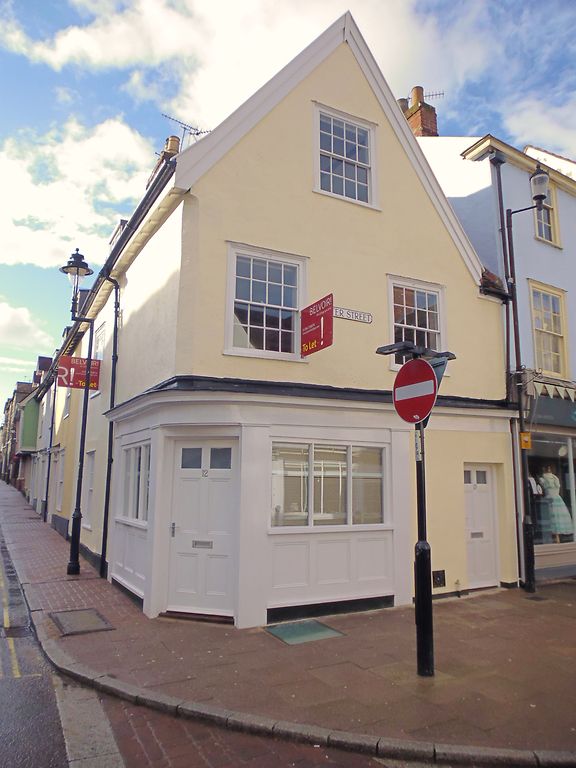
BURY ST EDMUNDS
TL8564SW HATTER STREET
639-1/14/422 (West side)
12/07/72 No.13
GV II
House and shop. Early C19 with an earlier core. Timber-framed
and rendered; plaintiled roof with a gable facing Hatter
Street. 3 bays; on a corner site, forming part of the row with
Nos 18, 19 and 20 Churchgate Street (qv).
EXTERIOR: 2 storeys, attic and cellar; 2 windows to the 1st
storey on the Hatter Street frontage and one on the Churchgate
Street front, all 16-pane sashes in flush cased frames. A
similar window in the apex of the gable. On the ground storey,
one blocked sash window, a shop front with a window facing
each street and a corner entrance. A wide fascia board above
the shop windows extends across the whole of the Hatter Street
frontage.
INTERIOR: the modernised cellar still retains a massive main
beam supporting the ceiling. Above ground, most timbers are
covered, but the side wall on the north has the main
components only, as if butted up against a pre-existent
building. Side-purlin roof.
Listing NGR: TL8540464054
External links are from the relevant listing authority and, where applicable, Wikidata. Wikidata IDs may be related buildings as well as this specific building. If you want to add or update a link, you will need to do so by editing the Wikidata entry.


Other nearby listed buildings
