Approximate Location Map
Large Map »
Latitude: 52.2435 / 52°14'36"N
Longitude: 0.7152 / 0°42'54"E
OS Eastings: 585472
OS Northings: 264069
OS Grid: TL854640
Mapcode National: GBR QF0.7NF
Mapcode Global: VHKD4.BVZZ
Plus Code: 9F426PV8+C3
Entry Name: 29, Churchgate Street
Listing Date: 12 July 1972
Grade: II
Source: Historic England
Source ID: 1248121
English Heritage Legacy ID: 466710
ID on this website: 101248121
Location: Bury St Edmunds, West Suffolk, IP33
County: Suffolk
District: West Suffolk
Civil Parish: Bury St Edmunds
Built-Up Area: Bury St Edmunds
Traditional County: Suffolk
Lieutenancy Area (Ceremonial County): Suffolk
Church of England Parish: Bury St Edmunds St Mary
Church of England Diocese: St.Edmundsbury and Ipswich
Tagged with: Building
BURY ST EDMUNDS
TL8564SW CHURCHGATE STREET
639-1/14/243 (North side)
12/07/72 No.29
GV II
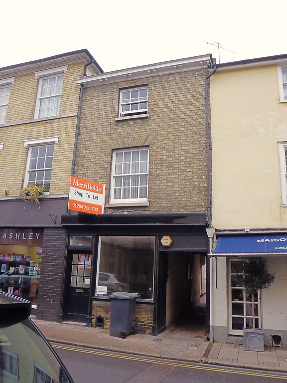
Shop with flat above, formerly a house. Mid C16 core, raised
and fronted in the early C19. Timber-framed and formerly
jettied, faced in white brick; slate roof with paired
modillion eaves soffit.
EXTERIOR: 3 storeys and cellar; one bay; extension at rear.
One window to each upper storey, a 16-pane sash with deep
reveals, flat gauged arch and stone sill to the 1st storey,
and a similar 6-pane sash to the 2nd storey. A small early C19
shop front, with fluted pilasters and a cornice fascia, has a
C20 plate glass window and is set between 2 flanking doors,
that on the right leading into a passageway divided off to
give access to the rear yard. Within the passageway an
original end wall with widely-spaced, substantial studs and
plain joists set flat. The main beam has bracketing for the
former jetty. Within the shop, a main beam in the side wall on
the west is chamfered on both sides, with curved step stops,
and originally formed the centre beam of a 2-bay room which
extended into what is now the adjoining property, No.28 (qv).
Listing NGR: TL8547164071
External links are from the relevant listing authority and, where applicable, Wikidata. Wikidata IDs may be related buildings as well as this specific building. If you want to add or update a link, you will need to do so by editing the Wikidata entry.


Other nearby listed buildings
