Approximate Location Map
Large Map »
Latitude: 52.2435 / 52°14'36"N
Longitude: 0.7151 / 0°42'54"E
OS Eastings: 585465
OS Northings: 264068
OS Grid: TL854640
Mapcode National: GBR QF0.7MB
Mapcode Global: VHKD4.BVXZ
Plus Code: 9F426PV8+C2
Entry Name: 28, Churchgate Street
Listing Date: 12 July 1972
Grade: II
Source: Historic England
Source ID: 1248120
English Heritage Legacy ID: 466709
ID on this website: 101248120
Location: Bury St Edmunds, West Suffolk, IP33
County: Suffolk
District: West Suffolk
Civil Parish: Bury St Edmunds
Built-Up Area: Bury St Edmunds
Traditional County: Suffolk
Lieutenancy Area (Ceremonial County): Suffolk
Church of England Parish: Bury St Edmunds St Mary
Church of England Diocese: St.Edmundsbury and Ipswich
Tagged with: Building
BURY ST EDMUNDS
TL8564SW CHURCHGATE STREET
639-1/14/242 (North side)
12/07/72 No.28
GV II
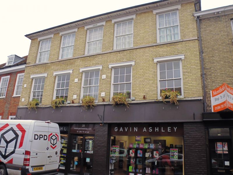
Shop with living accommodation above, formerly 2 houses. Dated
1835 on front; C16/C17 core. Timber-framed and rendered sides
and rear, white brick front; slate roof with paired bracketed
eaves soffit.
EXTERIOR: 3 storeys and cellar. 5 window range: all 12-pane
sashes in deep reveals with projecting stucco cornices on stub
brackets. Raised stucco bands run at sill level on both upper
storeys. The brick front was added to an earlier house; at the
rear is a double-gabled C17 wing, to which a Regency extension
with a large 2-storey semicircular flat-roofed bay was added.
This has a continuous range of three 12-pane sash windows with
cased frames and a heavy moulded cornice. The front range
replaces a C16 timber-framed house, part of which survives in
No.29 (qv), adjoining on the east. No original features are
exposed on the ground storey.
Listing NGR: TL8546564070
External links are from the relevant listing authority and, where applicable, Wikidata. Wikidata IDs may be related buildings as well as this specific building. If you want to add or update a link, you will need to do so by editing the Wikidata entry.


Other nearby listed buildings
