Approximate Location Map
Large Map »
Latitude: 52.2435 / 52°14'36"N
Longitude: 0.7156 / 0°42'56"E
OS Eastings: 585498
OS Northings: 264060
OS Grid: TL854640
Mapcode National: GBR QF0.7RR
Mapcode Global: VHKD4.CW51
Plus Code: 9F426PV8+96
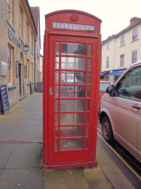
Entry Name: K6 Telephone Kiosk
Listing Date: 26 October 1987
Grade: II
Source: Historic England
Source ID: 1248300
English Heritage Legacy ID: 466728
ID on this website: 101248300
Location: Bury St Edmunds, West Suffolk, IP33
County: Suffolk
District: West Suffolk
Civil Parish: Bury St Edmunds
Built-Up Area: Bury St Edmunds
Traditional County: Suffolk
Lieutenancy Area (Ceremonial County): Suffolk
Church of England Parish: Bury St Edmunds St Mary
Church of England Diocese: St.Edmundsbury and Ipswich
Tagged with: K6 telephone box
BURY ST EDMUNDS
TL8564SW CHURCHGATE STREET
639-1/14/261 (South side)
26/10/87 K6 Telephone Kiosk
GV II
Telephone kiosk. Type K6. Designed 1935 by Sir Giles Gilbert
Scott. Cast-iron. A square kiosk with a domed roof.
Unperforated crowns to top panels and margin glazing to
windows and door.
Listing NGR: TL8549864060
External links are from the relevant listing authority and, where applicable, Wikidata. Wikidata IDs may be related buildings as well as this specific building. If you want to add or update a link, you will need to do so by editing the Wikidata entry.


Other nearby listed buildings
