Approximate Location Map
Large Map »
Latitude: 52.4004 / 52°24'1"N
Longitude: 0.2576 / 0°15'27"E
OS Eastings: 553687
OS Northings: 280435
OS Grid: TL536804
Mapcode National: GBR M6G.KY3
Mapcode Global: VHHJ6.FX0R
Plus Code: 9F42C725+42
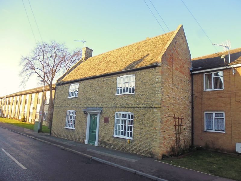
Entry Name: Lavender House
Listing Date: 19 June 1972
Grade: II
Source: Historic England
Source ID: 1252443
English Heritage Legacy ID: 435374
ID on this website: 101252443
Location: Ely, East Cambridgeshire, CB6
County: Cambridgeshire
District: East Cambridgeshire
Civil Parish: Ely
Built-Up Area: Ely
Traditional County: Cambridgeshire
Lieutenancy Area (Ceremonial County): Cambridgeshire
Church of England Parish: Ely
Church of England Diocese: Ely
Tagged with: House
1.
1082
TL 5380
1/55
WEST FEN ROAD
Lavender House
II
2.
A C18 brick house (possibly with an earlier structure incorporated),
partly demolished. Rebuilt at the rear in the C20, 2 storeys. 2 window
range, casements with glazing bars (C20). A raised brick band runs between
tile storeys. Roof tiled (Old Cambridgeshire tiles).
Listing NGR: TL5368780435
External links are from the relevant listing authority and, where applicable, Wikidata. Wikidata IDs may be related buildings as well as this specific building. If you want to add or update a link, you will need to do so by editing the Wikidata entry.


Other nearby listed buildings
