Approximate Location Map
Large Map »
Latitude: 52.4 / 52°23'59"N
Longitude: 0.2584 / 0°15'30"E
OS Eastings: 553747
OS Northings: 280394
OS Grid: TL537803
Mapcode National: GBR M6H.D66
Mapcode Global: VHHJ6.FYG2
Plus Code: 9F4297X5+X9
Entry Name: Waterloo House
Listing Date: 23 September 1950
Last Amended: 18 November 2016
Grade: II
Source: Historic England
Source ID: 1262318
English Heritage Legacy ID: 435370
ID on this website: 101262318
Location: Ely, East Cambridgeshire, CB6
County: Cambridgeshire
District: East Cambridgeshire
Civil Parish: Ely
Built-Up Area: Ely
Traditional County: Cambridgeshire
Lieutenancy Area (Ceremonial County): Cambridgeshire
Church of England Parish: Ely
Church of England Diocese: Ely
Tagged with: House
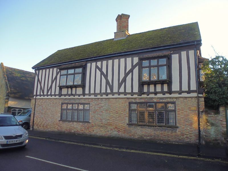
Timber-framed block of c1500 with a range of phases dating from C16-C20.
Four-bay, timber-framed block of c1500 with a range of subsequent phases dating from C16-C20.
MATERIALS: principally timber-framed with underbuilt brick ground-floor external walls and plain tile roof.
PLAN: splayed double-range plan with rectangular timber-framed block of c1500 fronting onto West Fen Road and a 1960s block set at an acute angle to the rear with a projecting modern conservatory to the south-west.
EXTERIOR: the West Fen Road frontage forms a four-bay, double-storied range with exposed timber-framing with close studding and tension braces to the first storey and the upper level of the gable end to the east. This range was originally jettied along the north elevation and the ends of the exposed joists remain, though this was underbuilt with the brick rebuilding of the ground floor external walls in the C18. The timber jetty post, which indicates the extent of the ground-floor prior to its underbuilding, is retained in the brickwork of the east gable end. At first-floor level the west, north and east elevations all feature oriel windows, which project outwards supported by curved brackets and set beneath tiled coverings. There is a two window range on the north front and single window range on the south front. The windows are rectangular oriel bay windows on curved brackets (for the first storey) and mullioned and transomed casements on the ground storey, all with leaded lattice lights and introduced c1920. The window on the south west-side has inserted an enriched bracket with carved figure. The roof structure of the front range was entirely rebuilt in the 1960s and the central brick double chimney stack, with diagonal shafts on a rectangular base, dates from this time.
INTERIOR: as constructed the front range consisted of two rooms on each floor with a notable difference in the status of the separate ends of the building, exemplified by the considerably more elaborate set of mouldings and timber detailing to the east side. The suggested original arrangement of the principal range remains broadly legible, the only notable alterations being the inserted late C16 central chimney stack, the repositioning of the stairs and the possibly C20 subdivision of the first-floor east room into two separate bedrooms.
At ground-floor level the range retains its pair of distinct rooms. That to the east has its ceiling quartered into four equal sections by its central cross beam and the spine beam, these featuring relatively elaborate moulding formed of a single ogee with a hollow chamfer below. The stops of the spine beams are concealed at their outer ends, and where they meet the cross beam they are not stopped but run through to form an intersecting cross. The stops on the cross beam have lower hollow chamfer moulding terminating in a step and run-out stop and the upper ogee moulding running down and into a stepped stop beyond this, though the joists here are all unmoulded. Along the north side of the range the cross beams have redundant notches for the jetty bressumer which would have run the length of the building prior to the underbuilding of the jetty. The jowled heads of original jetty posts also survive in situ, though the posts have been removed. The second and third trusses of the range are numbered with inscribed numerals starting from the east side of the room, this sequence continuing through into the western room with the fourth truss.
Much of the evidence for the front and east walls of this room is missing or concealed, but in the rear (south) wall of the east room retains its girding rail, with redundant mortices indicating the position of an original three-light window, and a set of three in situ studs - the only studs in situ at ground-floor level in the building. Occupying the western side of the east room is the later chimney stack, probably added later in the C16, although the fire surround here dates from the 1920s. The inserted stack partially truncates the unmoulded central cross beam of the range, though the remaining portion of this retains a series of redundant mortices on its underside - implying that this would have been the position of the original division between the east and west rooms.
The ground-floor western room has a similar arrangement to that to the east, with the central cross beam and two spine beams creating a quartered ceiling; these stopped at the intersection. Both have a plainer set of mouldings however, with a simple chamfer on the cross beam with a stepped and run out stop. The spine beam has a similar chamfer moulding. Its stops survive where they meet the cross beam but are of a quite unusual form; straight cut, but angled with the upper edge towards the chamfer. The joists are again unmoulded. In the southwest quadrant of the ceiling a short trimmer beam which projects out from the south girding rail probably indicates the position of an original stair; this was probably associated with an original entrance to this range. The fireplace in this room has a four-centred arched surround with a roll moulded base and foliate decoration in the spandrels, probably inserted in the 1920s. Stylistically this appears to imitate the first-floor eastern fireplace, which may have been an early feature in the building (see below). The elaborate picture-rail level oak panelling in this room is of C19 date, this apparently having been moved from a larger house and fitted here as part of the 1920s phase of work.
At first-floor level it is probable that the space was also divided into two equal rooms, though at this level tie beam of the central truss has been removed, so any evidence for an original internal partition on this alignment does not survive. The mouldings of trusses here are similar to the ground-floor, with the east room being of higher status, this giving evidence for two distinct spaces. The decorative elements of these trusses correspond to the beam mouldings at ground-floor level, with the eastern one formed of an ogee and hollow chamfer and the western one of a simple straight chamfer. Both also have residual evidence for braces rising from the posts to the tie beams, of which the second and fourth are again numbered with notched numerals, though these in reverse west-east order here (this probably representing the construction sequence). The eastern truss braces appear to have been more substantial than those to the west (as indicated by the residual brace pegging and the survival of the large central fillet on the underside of the tie beam). Above the tie beams the majority of the roof has been removed but one crown post survives over the display truss in the eastern room, this having been recently reset in its original position following temporary removal in the 1960s. Above the western room there is a residual mortice in the tie-beam for a smaller crown post, though this was removed in the 1960s.
The western room at first-floor level incorporates the full depth of the double stack within a contemporary (late C16) partition wall, dividing this smaller west room from its eastern counterpart. This partition is formed of timber studding, with several elements apparently reused as they show redundant mortices. These studs support an inserted cross beam, which does not bond into or rest upon either wall plate but rather sits above them supported only by the secondary studs. This has a simple chamfer on its outer edge, with straight stops. The stone fireplace here features a four-centred arched head including spandrels decorated with blank shields and distinctive carvings (apparently of a bulrush and another unidentified plant) and seems to date from the early C16, this probably introduced as part of the 1920s scheme along with the timber surround. The four-centred arched doorway of the western room is positioned south of the fireplace also dates from the 1920s and features decorative strap hinges.
The eastern side of the first-floor is subdivided into two distinct bedrooms with a corridor along the south wall formed to give access to the easternmost room. Both rooms have reset fielded panelled C18 doors and, in the central room, a C18 cupboard with a wavy splat baluster to its upper portion – these being the only remnants of a C18 phase in this range. The central room of this eastern side also has stone fireplace, with a four-centred arched head with roll moulding and spandrels above the arch which have an undulating leaf pattern typical of the late C16. It is possible that this is an original fireplace but given the range of reset features dating from the 1920s this cannot be confirmed. Two original studs are set in the north wall adjacent to the window in this room, this indicating that an original window here would have also been positioned off-centre towards the central truss of the room and no wider than the present window.
The eastern room has remaining evidence in the wall plate for the position of an original window in the rear south wall of the range. Two residual mortices survive here suggesting a two-mullion, three-light window. Above the window, running towards the post, there is a groove in the underside of the wall plate which indicates the position of a sliding shutter for the window. It appears that the other bays within this room comprised plain close studding, judging from the evidence of visible peg holes here.
To the rear of the main street-facing range is the south-west wing; this was entirely rebuilt in the 1960s on the plot of a much-altered earlier range which, in its earliest form, may have predated the front range of Waterloo House. The south wall is open at ground-floor level here to connect with this later wing and the C20 staircase between the two levels of the front range is set in this area. Whilst the plan of this rear wing occupies the same footprint as an earlier, possibly medieval range, no early fabric appears to be retained in this rebuilt portion of Waterloo House. This rear range is architecturally modest and a late addition and is consequently excluded from the listing.
The present city of Ely rises 20m above the surrounding fen on an island of Kimmeridge clay. Although well connected by river and waterways, until the C17 only causeways connected the island to the mainland, and in the early years of Christianity its isolation made it an ideal refuge for those seeking a secluded monastic life. The first successful attempt to establish a religious settlement here was made by Etheldreda in c673, re-endowed by King Edgar 100 years after its destruction by the Danes in 870. Despite threats of further invasion in the C11, and later political turmoil, this monastery survived until its dissolution in 1539. The presence of a monastic community occupying substantial buildings required the support of a lay community, and as that grew, so did the needs of the lay-people for accommodation and services. A detailed survey of 1416 recorded 457 buildings and described an established street pattern; by 1563 the number of households had grown to 800. Despite this growth in population, John Speed’s map of Ely, published in 1611/12, is very similar in both layout and extent to that of the first edition Ordnance Survey (OS) Map of 1885, where the only significant expansion is towards the railway (1845): however, in Speed’s map, houses lining the streets enclose spaces of apparently horticultural and even agricultural production, and while these are still present on the 1885 map they have been pushed to the margins of the city. These maps graphically illustrate the continuing importance of agriculture and agriculturally related industries in the early C17 and beyond, and also show that the later growth in population took place mainly within the confines of the early city street plan. Before the later C19, the only significant rival to agriculture was the pottery industry, in production from the C12 to 1860.
Following the dissolution of the monastery, Ely remained the centre of the diocese, but the loss of the community, and of pilgrims to the shrine of St Etheldreda, would have had a considerable impact on the city’s economy. The consequent decline in management of the fen and its waterways led to an increase in flooding, and attempts at drainage in the C17 and C18 seem to have had limited effect, creating constraints on the ability of the city to thrive. Successive literary travellers commented on the poor drainage, including Celia Fiennes in the mid-C17, who described the city as a “perfect quagmire”, and Daniel Defoe in the early C18, who noted both the city’s market gardens and its overflowing wells. By the mid-C19 the city was in a state of recovery and regeneration: several possible contributory factors include successful drainage, enclosure (1848) and the arrival of the railway with the opening of the Cambridge to Ely line in 1845. This was followed slightly later by other lines, making the city a transport hub. Despite this, the physical expansion of Ely beyond its medieval core was slow through the mid-C20, accelerating through the late C20 and into the C21, as Ely developed as a dormitory town for Cambridge.
Waterloo House, is close to the junction of West Fen Road and Downham Road, just to the north-west of the core of medieval Ely. Both of these roads were important thoroughfares in the medieval period, giving access to other settlements on the Isle of Ely and to the surrounding fenland. Archaeological evidence suggests that Saxon settlement at Ely may have been focused in this area, with C8 settlement activity found further to the west along West Fen Road (Holton Krayenbuhl, 2011, 5). The full extent and nature of this settlement is as yet undefined, but it is possible that the road developed as part of the network of trackways during that period. By the late medieval period the land around West Fen Road and Downham Road was in the ownership of the Bishop of Ely, and in the 1416/17 survey there were tenements on both sides of both roads. Settlement here was less intense than that in the centre and east of the city however, with larger plots and several areas of open land suggesting a more rural type of settlement (Holton Krayenbuhl, 2011, 133). Nonetheless the roads were still within close proximity of the important commercial thoroughfare along St Mary’s Street, illustrating the mixture of settlement types that occurred within close proximity in the medieval city.
The earliest evidence in the present Waterloo House is for a relatively high-status timber-framed range of c1500. In its original form it is suggested that the building would have been jettied towards the street with two rooms on each floor. It is probable that when built the street-facing range would have formed a component of a larger complex. It is possible that the c1500 range was added to an earlier medieval hall range in order to create a new frontage to West Fen Road as this developed as a key thoroughfare into Ely. It is known that the present 1960s block set at an acute angle to the rear replaced an earlier wing on the same footprint, and it is probable that the earlier medieval hall range would have occupied this same plot before being replaced in around the C17 which was then subsequently rebuilt. This suggested historical development of the site remains speculative, but does give an explanation for the unusual acute angle of the two wings. The arrangement outlined here is supported by the similar plan seen at Oliver Cromwell’s House Museum on St Mary’s Street (approximately 100m south), where a similar arrangement exists.
Since construction in c1500 Waterloo House has seen several notable phases of development. A significant early alteration was the insertion of a central chimney stack, probably introduced late in the C16. It is unclear how the building would have been heated prior to this phase, it is possible that an original timber-framed stack occupying the same position may have been replaced at this time, though even by 1500 such features would have been uncommon. Alternatively, a stack may have been set into the south wall of the building in the second bay from the east, although if this was the case it probably heated only the higher-status ground-floor room. The main evidence for this position is the lack of residual pegging on the girding rail in this position which suggests a relatively wide opening in the wall here, though this evidence is not conclusive enough to be certain of this. At approximately the same time the new stack was constructed, several associated alterations were likely to also have been made, probably including the removal of the original stair in the western room and the ceiling over of the first-floor rooms.
The most significant change to the outward appearance of Waterloo House came in the C17, with the outbuilding of the ground-floor front wall to replace the jettied profile of the West Fen Road frontage with a fashionable straight profile façade. It is likely that subsequent alterations were made in the C18, of which the only surviving elements are the pair of panelled room doors and a cupboard in the first-floor east room. This phase included the construction of the cart shed sitting to the east of the cross wing (listed Grade II), though any other work of this period in the main range has since been replaced the substantial renovation work undertaken early in the C20. Stylistically this work, probably undertaken in the 1920s, owes much to the Arts and Crafts movement. As part of this phase some early historic features were introduced to the house, as well as a significant number of well-designed features of the period and a new set of diamond-leaded casement windows.
Into the 1960s, the building, particularly the rear wing, had fallen into a poor state of repair. At this time the rear wing entirely demolished and rebuilt on the same footprint. As part of this phase the roof of the main range was also entirely rebuilt, although one of the crown posts was retained, initially in the garden before being returned to the house in the last five years. Internally the only significant alteration of this phase was the subdivision of the first-floor east room into two smaller rooms.
In the original September 1950 List entry, Waterloo House, it was described as: ‘A C16 timber framed and plastered house, originally built on an L shaped plan. A wing at the rear on the west end has been rebuilt in the C20. Much altered and restored. 2 storeys. The front block has exposed timber-framing on the 1st storey, which was originally jettied, the ends of the exposed joists still show. The ground storey was built out in brick. 2 window range on the north east front and 1 window range on the south west front, rectangular oriel bay windows on curved brackets on the first storey and C20 mullioned and transomed casements on the ground storey, all with C20 leaded lattice lights. The window on the south west side has inserted an enriched bracket with carved figure. Roof tiled, with a central chimney stack (rebuilt) with diagonal shafts on a rectangular base. The interior has good moulded ceiling beams and exposed framing.’
Waterloo House, 3 West Fen Road, is listed at Grade II for the following principal reasons:
* Architectural interest: as a relatively high-status, timber-framed block of c1500 with a range of subsequent phases covering over four centuries. Surviving fabric and structural detail from each phase reflects the changing needs of succeeding occupants, thus providing important evidence for historic building traditions;
* Historic interest: it lies within the area of settlement described on John Speed’s map of 1610/1611, a street pattern established by the early C15, and makes an important contribution to the historical development of the townscape;
* Group value: it lies within the Ely Conservation Area, and is one of 198 listed buildings in the city, thus forming part of a collection which illustrates building traditions spanning several centuries.
External links are from the relevant listing authority and, where applicable, Wikidata. Wikidata IDs may be related buildings as well as this specific building. If you want to add or update a link, you will need to do so by editing the Wikidata entry.


Other nearby listed buildings
