Latitude: 51.8475 / 51°50'50"N
Longitude: -1.3577 / 1°21'27"W
OS Eastings: 444341
OS Northings: 216739
OS Grid: SP443167
Mapcode National: GBR 7WH.5K5
Mapcode Global: VHCX6.FT3L
Plus Code: 9C3WRJWR+XW
Entry Name: Number 9 and Attached Walls and Outbuilding
Listing Date: 18 October 1949
Last Amended: 27 July 1988
Grade: II
Source: Historic England
Source ID: 1252571
English Heritage Legacy ID: 435574
ID on this website: 101252571
Location: Woodstock, West Oxfordshire, OX20
County: Oxfordshire
District: West Oxfordshire
Civil Parish: Woodstock
Built-Up Area: Woodstock
Traditional County: Oxfordshire
Lieutenancy Area (Ceremonial County): Oxfordshire
Church of England Parish: Woodstock
Church of England Diocese: Oxford
Tagged with: Building
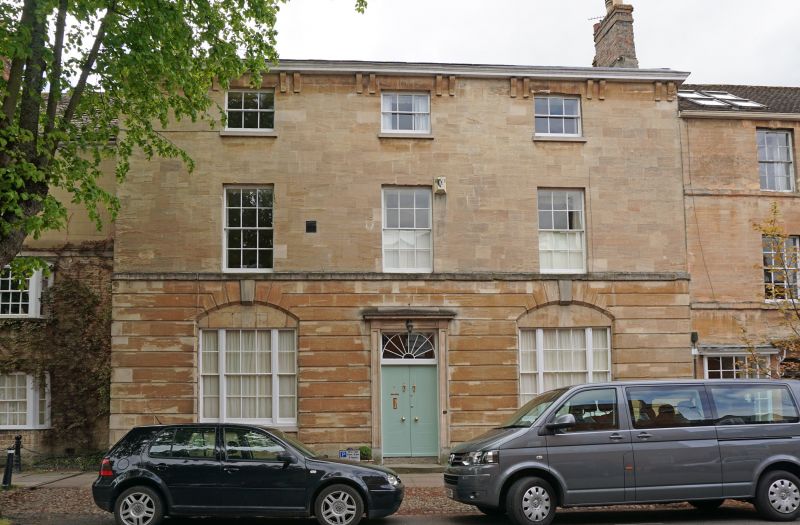
WOODSTOCK PARK STREET SP4416NW (South side) 9/226 No.9 and attached walls and 18/10/49 outbuilding (Formerly listed as Old Town House) GV II Two houses, now house. C17. House to right of c.1810 for Henry North, town clerk. Coursed limestone rubble. Ashlar front, with banded rustication to ground floor. Gabled Welsh slate roof; end stacks of rendered stone finished in brick. Double-depth plan. Late Georgian style. 3 storeys; symmetrical 3-window range. Early C19 beaded double doors with decorative overlight set in bracketed architrave with revealed panels. Keyed segmental tympanum arches over tripartite sashes with glazing bars. Raised storey band; flat arches over 6-pane sashes to first floor and 3-pane sashes to second floor; bracketed cornice. C17 house to left, remodelled in C19: of coursed limestone rubble with stuccoed upper storey and stone slate roof: 3-storey, one-window range has canted 2-storey bay window with 8-pane sashes; early C19 eight-pane sash above. Rear wall of C17 house heightened in mid C19 brick. C19 sashes and casements to rear. Interior: early C19 panelled dado in central hall; dentilled cornice and early C19 fireplace in room to right; early C19 quarter-turn stairs with winders and stick balusters in hall to rear. C17 house to left noted as having heavy chamfered beams. Subsidiary features: brick walls enclose garden approximately 50 x 10 metres to rear; of early C19 rat-trap Flemish bond to left. Mid/late C18 English garden wall bond with limestone rubble to rear wall adjoining Rectory Lane (q.v.). Early C19 outbuilding to rear, of brick and limestone rubble with concrete tile roof, is attached to outbuilding facing Rectory Lane of limestone rubble with half-hipped stone slate roof. (Information from VCH)
Listing NGR: SP4434116739
External links are from the relevant listing authority and, where applicable, Wikidata. Wikidata IDs may be related buildings as well as this specific building. If you want to add or update a link, you will need to do so by editing the Wikidata entry.


Other nearby listed buildings