Latitude: 53.3762 / 53°22'34"N
Longitude: -1.4996 / 1°29'58"W
OS Eastings: 433388
OS Northings: 386712
OS Grid: SK333867
Mapcode National: GBR 98M.ZJ
Mapcode Global: WHCCJ.YD2K
Plus Code: 9C5W9GG2+F5
Entry Name: West Mount and Attached Wall
Listing Date: 28 June 1973
Grade: II
Source: Historic England
Source ID: 1254956
English Heritage Legacy ID: 458430
ID on this website: 101254956
Location: Broomhill, Sheffield, South Yorkshire, S10
County: Sheffield
Electoral Ward/Division: Broomhill and Sharrow Vale
Parish: Non Civil Parish
Built-Up Area: Sheffield
Traditional County: Yorkshire
Lieutenancy Area (Ceremonial County): South Yorkshire
Church of England Parish: Sheffield Broomhill St Mark
Church of England Diocese: Sheffield
Tagged with: Architectural structure
SHEFFIELD
SK3386NW GLOSSOP ROAD 784-1/26/377 (South side) 28/06/73 No.463 West Mount and attached wall
II
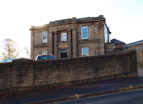
House, now offices, and attached wall. c1840, refenestrated late C20. Ashlar with rendered right return. Roof not visible. Classical Revival style. Plinth, corner pilasters, first floor band, cornice and blocking course. 2 storeys; 3 window range of plain sashes. Single bay projecting centre with giant Ionic columns in antis, flanking a single window. Below, moulded doorcase with paterae and C20 glazed door with overlight. On each side, a single window. INTERIOR has saucer domed stairwell with spiral stone stair with cast-iron balusters and newel. Hallway and ground floor room have enriched cornices and pilasters.
Listing NGR: SK3338886712
External links are from the relevant listing authority and, where applicable, Wikidata. Wikidata IDs may be related buildings as well as this specific building. If you want to add or update a link, you will need to do so by editing the Wikidata entry.


Other nearby listed buildings