Approximate Location Map
Large Map »
Latitude: 51.1498 / 51°8'59"N
Longitude: 0.6903 / 0°41'25"E
OS Eastings: 588255
OS Northings: 142387
OS Grid: TQ882423
Mapcode National: GBR QV4.TLG
Mapcode Global: VHJN2.XC9F
Plus Code: 9F324MXR+W4
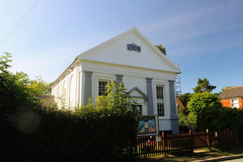
Entry Name: The Zion Chapel
Listing Date: 10 October 1980
Grade: II
Source: Historic England
Source ID: 1362692
English Heritage Legacy ID: 181271
ID on this website: 101362692
Location: Smarden, Ashford, Kent, TN27
County: Kent
District: Ashford
Civil Parish: Smarden
Built-Up Area: Smarden
Traditional County: Kent
Lieutenancy Area (Ceremonial County): Kent
Tagged with: Chapel
1.
5272 SMARDEN THE STREET
(south side)
The Zion Chapel
TQ 8842 29/14
II GV
2.
Dated 1841. Stuccoed front. Four pilasters on tall bases support a cornice
and a pediment with the inscription 'Zion'. Two tall thin windows with glazing
bars intact. Doorcase in moulded architrave surround, with pediment over on
brackets and double door of 6 fielded panels.
Listing NGR: TQ8825542387
External links are from the relevant listing authority and, where applicable, Wikidata. Wikidata IDs may be related buildings as well as this specific building. If you want to add or update a link, you will need to do so by editing the Wikidata entry.


Other nearby listed buildings
