Approximate Location Map
Large Map »
Latitude: 53.8348 / 53°50'5"N
Longitude: -1.5835 / 1°35'0"W
OS Eastings: 427507
OS Northings: 437691
OS Grid: SE275376
Mapcode National: GBR B85.H4
Mapcode Global: WHC95.NW52
Plus Code: 9C5WRCM8+WJ
Entry Name: Gate Piers, Gates, Flanking Wall and Bollards to Number 89
Listing Date: 11 September 1996
Grade: II
Source: Historic England
Source ID: 1255744
English Heritage Legacy ID: 465687
ID on this website: 101255744
Location: Weetwood, Leeds, West Yorkshire, LS16
County: Leeds
Electoral Ward/Division: Weetwood
Parish: Non Civil Parish
Built-Up Area: Leeds
Traditional County: Yorkshire
Lieutenancy Area (Ceremonial County): West Yorkshire
Church of England Parish: Far Headingley St Chad
Church of England Diocese: Leeds
LEEDS
SE23NE WEETWOOD LANE, Weetwood
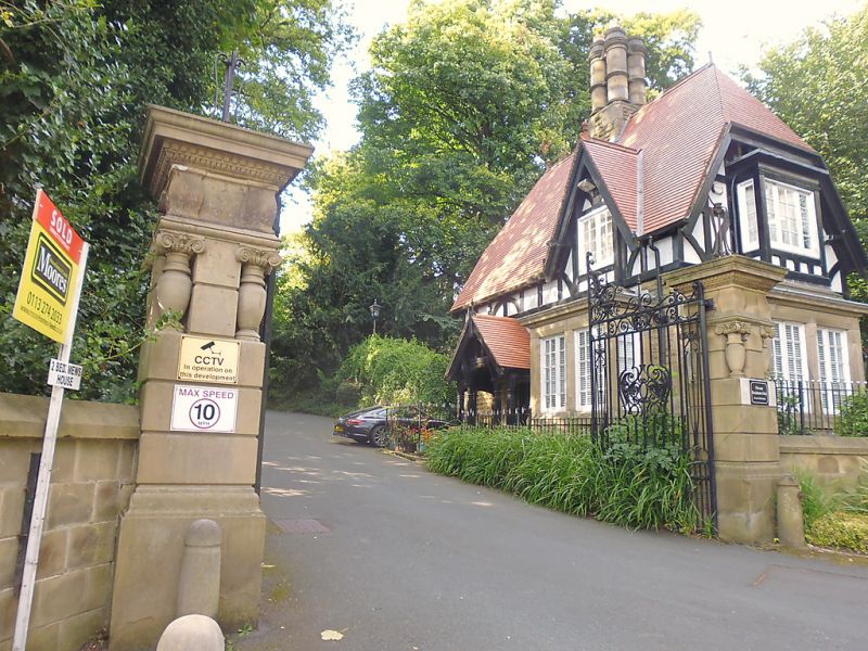
714-1/6/1223 (West side)
Gate piers, gates, flanking wall,
and bollards to No.89
GV II
Gate piers, gates, flanking walls and bollards. Dated 1902.
For Joseph Pickering. Wrought-iron gates, walling of ashlar
and coursed gritstone, stone bollards, chains missing.
Gates: 2 leaves, bars and dog bars, elaborate wrought-iron
scrolled panel to centre of each gate, scrolled frames and
crest with date.
Gate piers: rusticated ashlar, plinth, squat bulbous corner
shafts, entablature and deep moulded cornice similar to that
on the adjacent lodge, No.89, bay window (qv); flat capstones
with remains of wrought-iron lamp supports.
Walling: to north a low ashlar wall with moulded coping,
approx 10m long, curved to meet rusticated pier; to south the
wall is approx 2.5m high and 10m long, of coursed gritstone
and probably the remains of the earlier estate boundary, with
roll-moulded coping ramped down at left end; a gateway with
plain ashlar surround and board door with decorative cast-iron
panel above in this stretch.
Bollards: approx 0.7m high, 6 to left and 4 to right of gates,
conical with flattened ball finials.
Built as the entrance gates to Brandon Hill, now St Urban's
School.
Included for group value.
Listing NGR: SE2750737690
External links are from the relevant listing authority and, where applicable, Wikidata. Wikidata IDs may be related buildings as well as this specific building. If you want to add or update a link, you will need to do so by editing the Wikidata entry.


Other nearby listed buildings
