Approximate Location Map
Large Map »
Latitude: 53.7939 / 53°47'38"N
Longitude: -1.5418 / 1°32'30"W
OS Eastings: 430279
OS Northings: 433165
OS Grid: SE302331
Mapcode National: GBR BKM.CR
Mapcode Global: WHC9D.9W1W
Plus Code: 9C5WQFV5+H7
Entry Name: Leeds Bridge
Listing Date: 8 May 1974
Grade: II
Source: Historic England
Source ID: 1255873
English Heritage Legacy ID: 465558
ID on this website: 101255873
Location: Steander, Leeds, West Yorkshire, LS10
County: Leeds
Electoral Ward/Division: City and Hunslet
Parish: Non Civil Parish
Built-Up Area: Leeds
Traditional County: Yorkshire
Lieutenancy Area (Ceremonial County): West Yorkshire
Church of England Parish: Leeds City
Church of England Diocese: Leeds
Tagged with: Road bridge
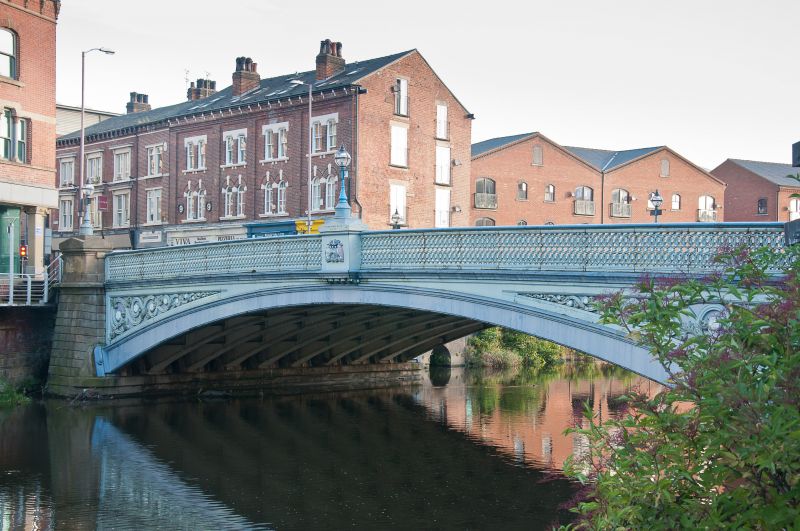
LEEDS
SE3033SW BRIDGE END
714-1/78/57 Leeds Bridge
08/05/74
GV II
Road bridge over River Aire. 1870-73. By T Dyne Steel,
engineer. Steel buckle plate deck supported on wrought-iron
internal arch ribs of compound riveted section; cast-iron
fascia arch ribs, rusticated ashlar abutments. Segmental arch
with scrolled motif in spandrels, parapet with interlocking
circles and moulded rail; coat of arms of Leeds at centre.
The oldest crossing point in the town, the site of the
medieval and later cloth markets and until 1818 the only dry
crossing of the river. The Aire was bridged at 5 other points
between 1818 and 1870 but it was estimated (c1869) that each
Saturday 4,000 vehicles and 55,000 foot passengers crossed
Leeds Bridge into the town. The cost of replacement was more
than »50,000 and many of the buildings on the approach roads
south of the river were replaced at that time.
(Fraser D: A History of Modern Leeds: 1980-: 137; Construction
details supplied by LCC Highways).
Listing NGR: SE3027933165
External links are from the relevant listing authority and, where applicable, Wikidata. Wikidata IDs may be related buildings as well as this specific building. If you want to add or update a link, you will need to do so by editing the Wikidata entry.


Other nearby listed buildings
