Approximate Location Map
Large Map »
Latitude: 53.7938 / 53°47'37"N
Longitude: -1.5412 / 1°32'28"W
OS Eastings: 430318
OS Northings: 433156
OS Grid: SE303331
Mapcode National: GBR BKM.HS
Mapcode Global: WHC9D.9WBY
Plus Code: 9C5WQFV5+GG
Entry Name: Simpsons Fold Warehouse
Listing Date: 5 August 1976
Last Amended: 11 September 1996
Grade: II
Source: Historic England
Source ID: 1375350
English Heritage Legacy ID: 466245
ID on this website: 101375350
Location: Steander, Leeds, West Yorkshire, LS10
County: Leeds
Electoral Ward/Division: City and Hunslet
Parish: Non Civil Parish
Built-Up Area: Leeds
Traditional County: Yorkshire
Lieutenancy Area (Ceremonial County): West Yorkshire
Church of England Parish: Hunslet St Mary the Virgin
Church of England Diocese: Leeds
Tagged with: Warehouse
LEEDS
SE3033SW DOCK STREET
714-1/78/154 (North side (off))
05/08/76 Simpson's Fold Warehouse
(Formerly Listed as:
DOCK STREET, Aire And Calder Dock
(North side)
Simpson's Fold Warehouse)
GV II
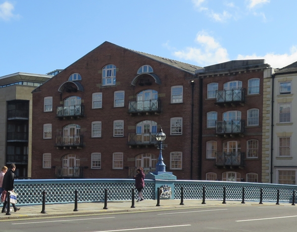
2 warehouses, now storage for Waterways Board. Early C19, with
C20 alterations. Ashlar plinth to basement, red brick above,
stone dressings, slate roof to main block, C20 tile roof to
north side infill block.
South, entrance front: 4 storeys with attic, 4 segmental-arch
openings to gable facade, 7 to side wall obscured by added
range, lower 2 storeys white painted. Gable: a tier of loading
doors to right of centre, platforms and rails, inserted
loading door to first floor left; small-pane windows, some
openings blocked; attic storey: central loading door flanked
by lunette windows, pulley above. Projecting band at first,
and 2nd-floor levels.
Rear (to river): left gable of main block has 2 tiers of
loading doors with platforms on brackets flanked by former
sashes, the lower half of the windows bricked up; segmental
arches to all openings; over both top doorways is an iron
pulley under a segmental-arch canopy, lunette window above;
narrower central loading door to gable, stone sills
throughout.
Infill block to right: 5 storeys, central loading doors with
stone platforms on brackets flanked by 16-pane sashes, all
openings have moulded brick segmental arches and reveals;
heavy stone modillion cornice with pedimented parapet, brick
stack. Right return: 7 openings, part obscured by adjacent
building, the right 4-window section breaking forward, the
left having a tier of loading doors flanked by sashes as north
gable; first-floor band carried round from front.
INTERIOR: not inspected.
The plan of the buildings is shown on the 1847 Ordnance Survey
map.
Listing NGR: SE3031833156
External links are from the relevant listing authority and, where applicable, Wikidata. Wikidata IDs may be related buildings as well as this specific building. If you want to add or update a link, you will need to do so by editing the Wikidata entry.


Other nearby listed buildings
