Latitude: 53.8173 / 53°49'2"N
Longitude: -1.5674 / 1°34'2"W
OS Eastings: 428576
OS Northings: 435750
OS Grid: SE285357
Mapcode National: GBR BCC.XD
Mapcode Global: WHC9C.W9SZ
Plus Code: 9C5WRC8M+W2
Entry Name: 50 and 52, Headingley Lane
Listing Date: 5 August 1976
Last Amended: 11 September 1996
Grade: II
Source: Historic England
Source ID: 1255988
English Heritage Legacy ID: 465385
ID on this website: 101255988
Location: Headingley Hill, Leeds, West Yorkshire, LS6
County: Leeds
Electoral Ward/Division: Headingley
Parish: Non Civil Parish
Built-Up Area: Leeds
Traditional County: Yorkshire
Lieutenancy Area (Ceremonial County): West Yorkshire
Church of England Parish: Headingley St Michael
Church of England Diocese: Leeds
Tagged with: House
LEEDS
SE2835NE HEADINGLEY LANE, Headingley
714-1/65/768 (North East side)
05/08/76 Nos.50 AND 52
(Formerly Listed as:
HEADINGLEY LANE, Headingley
(North East side)
Nos.50 AND 52
Laurieston Primary School and
Hillside)
GV II
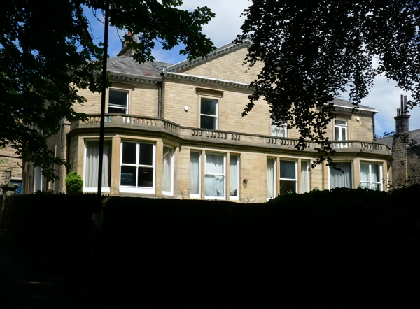
Semi-detached house, in use as a school and polytechnic
premises at the time of listing.
Mid C19 with later C19 alterations. Ashlar, slate hipped roof. 2
storeys, S front with 1:2:1 windows, the centre 2 project with
large pediment over, added canted bay windows to ground floor
with large 3-light windows between and balustrade over.
First-floor windows have plate-glass sashes, architraves with
entablature and cornice. Modillion eaves cornice, large
corniced ridge stacks flank central bay and at each end. Left
return (No.52): 3 bays, central 6-panel door, overlight with
interlaced glazing bars, in stone surround with shallow
pediment with acroteria; flanking and 1st-floor plain
surrounds to windows.
INTERIOR: not inspected.
The 1850 OS map shows the pair of houses with a drive each
side to the rear service buildings and dividing wall through
the front garden.
Listing NGR: SE2857635750
External links are from the relevant listing authority and, where applicable, Wikidata. Wikidata IDs may be related buildings as well as this specific building. If you want to add or update a link, you will need to do so by editing the Wikidata entry.


Other nearby listed buildings