Latitude: 53.8187 / 53°49'7"N
Longitude: -1.5635 / 1°33'48"W
OS Eastings: 428836
OS Northings: 435911
OS Grid: SE288359
Mapcode National: GBR BDB.RW
Mapcode Global: WHC9C.Y8NW
Plus Code: 9C5WRC9P+FJ
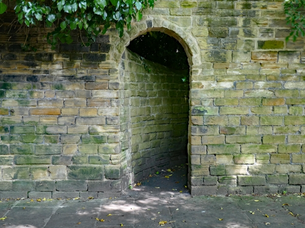
Entry Name: Gates, Gate Piers and Boundary Walls to Road and Right of Way, Ridgeway House
Listing Date: 11 September 1996
Grade: II
Source: Historic England
Source ID: 1256130
English Heritage Legacy ID: 465251
ID on this website: 101256130
Location: Woodhouse Cliff, Leeds, West Yorkshire, LS6
County: Leeds
Electoral Ward/Division: Headingley
Parish: Non Civil Parish
Built-Up Area: Leeds
Traditional County: Yorkshire
Lieutenancy Area (Ceremonial County): West Yorkshire
Church of England Parish: Woodhouse and Wrangthorn
Church of England Diocese: Leeds
Tagged with: Gate
LEEDS
SE2835NE GROSVENOR ROAD, Headingley 714-1/65/750 (West side) Gates, gate piers and boundary walls to road and right of way, Ridgeway House
GV II
Boundary walls and gateways. c1848. Coursed squared gritstone, ashlar walling flanking gateway, wrought-iron and wooden gates. Enclosing and dividing the grounds of Ridgeway House, Cumberland Road (qv), with main gateway on Grosvenor Road, archway to ginnel on Cumberland Road, and gateway to grounds on Cumberland Road. Overall length approx 400m, composed of the following lengths: i) walling on the W side of Grosvenor Road between the gates and railings to Hilly Ridge House (qv) and the entrance to the right of way to the S; overall length approx 50m, height 2.5m; the entrance gateway to Ridgeway House comprises outer gritstone piers with moulded flat capstones, dressed stone walling with shallow pointed coping, inner square piers in vermiculated rustication, moulded cornice and ball finials, spur stones at bases, paired wrought-iron gates with dog bars, X-braces, leaf finials to bars. ii) walls flanking the narrow pedestrian right of way through the grounds of Ridgeway House: overall length approx 100m, height 3m, rounded coping stones; a single-slab footbridge crosses the path near the western end. iii) the walling along the W side of the grounds, overall length approx 150m, height 3m, from the junction with the house: an angled wall with the remains of 3 blind/blocked arches, flat coping, to the entrance to Elmfield (qv). This length of walling includes the round-arched opening to the right-of-way and the gate piers and gates into the former gardens of Ridgeway House. Monolithic piers with modillion cornice and flat capstones, wooden gates with remains of L-hinges. The routeway from Leeds and Woodhouse to hamlets and mills outside the town is shown on early maps and was protected when the development of this part of the Revd Richard Fawcett's estates took place after 1846. The N wall of the pathway forms a revetment to the house garden which was planted with shrubs to hide the wall top. (The Rise of Suburbia (Thompson FML, Ed): Treen, C: The process of suburban development in North Leeds, 1870-1914: Leicester UP: 1982-: 158-209).
Listing NGR: SE2883635911
External links are from the relevant listing authority and, where applicable, Wikidata. Wikidata IDs may be related buildings as well as this specific building. If you want to add or update a link, you will need to do so by editing the Wikidata entry.


Other nearby listed buildings