Latitude: 53.8182 / 53°49'5"N
Longitude: -1.563 / 1°33'46"W
OS Eastings: 428866
OS Northings: 435857
OS Grid: SE288358
Mapcode National: GBR BDC.V2
Mapcode Global: WHC9C.Y9W7
Plus Code: 9C5WRC9P+7Q
Entry Name: Boundary Wall to West of Number 5 Grosvenor Terrace
Listing Date: 5 August 1976
Last Amended: 11 September 1996
Grade: II
Source: Historic England
Source ID: 1256091
English Heritage Legacy ID: 465258
ID on this website: 101256091
Location: Woodhouse Cliff, Leeds, West Yorkshire, LS6
County: Leeds
Electoral Ward/Division: Headingley
Parish: Non Civil Parish
Built-Up Area: Leeds
Traditional County: Yorkshire
Lieutenancy Area (Ceremonial County): West Yorkshire
Church of England Parish: Woodhouse and Wrangthorn
Church of England Diocese: Leeds
Tagged with: Wall
LEEDS
SE2835NE GROSVENOR ROAD, Headingley
714-1/65/753 (West side)
05/08/76 Boundary wall to west of No.5
Grosvenor Terrace
(Formerly Listed as:
GROSVENOR ROAD, Headingley
Grosvenor Terrace Nos 1-5 incl walls
to E & W along Cliff Lane &
Grosvenor Road)
GV II
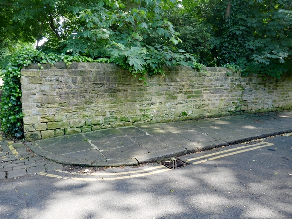
Boundary wall with gate piers and gates. Mid C19. Gritstone
wall, wrought-iron gates. Wall approx 80m long, rounded coping
stones, line broken by gate piers to No.1, square with pyramid
cap; aligned N-S and turning at S end to meet a pair of gates
with monolithic piers, the left pier broken. Gates of 2
leaves, bars, dog bars, leaf finials.
With the E wall (qv) the grounds of Grosvenor Terrace were
enclosed with a communal drive along the S side; the turn in
the wall indicates the line of the diagonal track which linked
the settlement at Woodhouse Cliff with Batty's Wood and mills
on Meanwood Beck.
Included for group value.
(Map of Leeds 1850).
Listing NGR: SE2886635857
External links are from the relevant listing authority and, where applicable, Wikidata. Wikidata IDs may be related buildings as well as this specific building. If you want to add or update a link, you will need to do so by editing the Wikidata entry.


Other nearby listed buildings