Latitude: 53.818 / 53°49'4"N
Longitude: -1.5639 / 1°33'50"W
OS Eastings: 428808
OS Northings: 435834
OS Grid: SE288358
Mapcode National: GBR BDC.N4
Mapcode Global: WHC9C.Y9GD
Plus Code: 9C5WRC9P+5C
Entry Name: Elmfield
Listing Date: 11 September 1996
Grade: II
Source: Historic England
Source ID: 1375299
English Heritage Legacy ID: 466194
ID on this website: 101375299
Location: Woodhouse Cliff, Leeds, West Yorkshire, LS6
County: Leeds
Electoral Ward/Division: Headingley
Parish: Non Civil Parish
Built-Up Area: Leeds
Traditional County: Yorkshire
Lieutenancy Area (Ceremonial County): West Yorkshire
Church of England Parish: Woodhouse and Wrangthorn
Church of England Diocese: Leeds
Tagged with: House
LEEDS
SE2835NE CUMBERLAND ROAD, Headingley
714-1/65/731 (East side)
Nos.12 AND 13
Elmfield
GV II
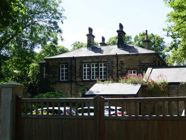
House, now University of Leeds premises. 1846. By Thomas Shaw.
probably later C19 additions. Coursed squared stone, blue
slate hipped roof.
2 storeys, 3 bays. Central pilastered porch with half-glazed
double doors, entablature, modillion cornice. Left: a
single-storey canted bay window with cornice similar to porch;
right: a 2-storey square bay with 2-light window to each
storey, a segmental moulding and carved panel above the
ground-floor window, dentilled cornice and blocking course to
1st floor. Centre and left, 1st floor: a single and a 2-light
window in moulded architraves; continuous sill moulding.
Modillion eaves cornice. Tall dentilled stacks to left and
right, behind ridge line.
INTERIOR: not inspected.
Built for the architect, this is probably the 'Enfield'
occupied by Mrs Hammond c1881 and Thomas Hammond, dyer, of
Cumberland Road, c1878. The porch and canted bay window are
possibly later additions. (Janet Douglas, Victorian Society,
pers. comm.).
(Ordnance Survey Map of Leeds, 6" scale: 1850-; McCorquodale:
Directory of Leeds: 1878-; Kelly's Directory of Leeds: 1881-).
Listing NGR: SE2880835834
External links are from the relevant listing authority and, where applicable, Wikidata. Wikidata IDs may be related buildings as well as this specific building. If you want to add or update a link, you will need to do so by editing the Wikidata entry.


Other nearby listed buildings